fncceo
Diamond Member
- Nov 29, 2016
- 43,159
- 35,927
- 3,615
Trump really raped that entire area,
That's a lot of Irish to rape. I have to imagine his stamina.

Even if I don't admire his taste.
Follow along with the video below to see how to install our site as a web app on your home screen.
Note: This feature may not be available in some browsers.
Trump really raped that entire area,
My what a dumb ass you remain, Mr. Westwall. You really think that we cannot tell the difference between river erosion, and that caused by sea level rise and permafrost thaw?Yes, erosion caused by sea level rise and thawing permafrost. You are such a dumb ass.It's called erosion. Look it up fool.
You didn't read the link either dumb ass. Read the link I provided and learn something.


Paul Laustsen and Ann Gibbs
July–Sept. 2015
in this issue:
next story
In a new study published July 2015, scientists from the U.S. Geological Survey (USGS) found that the remote northern Alaska coast has some of the highest shoreline-erosion rates in the nation. Analyzing more than half a century of shoreline-change data, scientists discovered that the pattern is extremely variable, with most of the coast retreating at rates of more than 1 meter per year.
Above: Shaded-relief map of the north coast of Alaska showing study area (U.S.-Canadian border to Icy Cape; rectangular box) and selected geographic locations. Modified from figure 1 of "National Assessment of Shoreline Change: Historical Shoreline Change Along the North Coast of Alaska, U.S.-Canadian Border to Icy Cape." [larger version]
"Coastal erosion along the Arctic coast of Alaska is threatening Native Alaskan villages, sensitive ecosystems, energy- and defense-related infrastructure, and large tracts of Native Alaskan, State, and Federally managed land," said Suzette Kimball, acting director of the USGS.
Scientists studied more than 1,600 kilometers of the Alaskan coast between the U.S.-Canadian border and Icy Cape, Alaska, and found that the average rate of shoreline change, taking into account beaches that are both eroding and expanding, was a loss of 1.4 meters per year. Of those beaches that are eroding, the most extreme case exceeded 18.6 meters per year.
Above: North coast of Alaska study area showing color-coded shoreline-change rates, boundaries of the 10 analysis regions (dashed boxes and numbers) used in the study, and key geographic locations. Figure 72 in "National Assessment of Shoreline Change: Historical Shoreline Change Along the North Coast of Alaska, U.S.-Canadian Border to Icy Cape." [larger version]
"This report provides invaluable objective data to help Native communities, scientists, and land managers understand natural changes and human impacts on the Alaskan coast," said Ann Gibbs, USGS geologist and lead author of the new report.
Coastlines change in response to a variety of factors, including changes in the amount of available sediment, storm impacts, sea-level rise, and human activities. How much a coast erodes or expands in any given location is due to some combination of these factors, which vary from place to place.
Northern Alaska Coastal Erosion Threatens Habitat and Infrastructure
And I can give you many more articles from scientific sources saying exactly the same thing.
Indeed they do, and the records go back over thirty years, and the rate of erosion now, is no different from what it was back then. Which blows your assertion right out of the water.
My what a dumb ass you remain, Mr. Westwall. You really think that we cannot tell the difference between river erosion, and that caused by sea level rise and permafrost thaw?Yes, erosion caused by sea level rise and thawing permafrost. You are such a dumb ass.It's called erosion. Look it up fool.
You didn't read the link either dumb ass. Read the link I provided and learn something.
Paul Laustsen and Ann Gibbs
July–Sept. 2015
in this issue:
next story
In a new study published July 2015, scientists from the U.S. Geological Survey (USGS) found that the remote northern Alaska coast has some of the highest shoreline-erosion rates in the nation. Analyzing more than half a century of shoreline-change data, scientists discovered that the pattern is extremely variable, with most of the coast retreating at rates of more than 1 meter per year.
Above: Shaded-relief map of the north coast of Alaska showing study area (U.S.-Canadian border to Icy Cape; rectangular box) and selected geographic locations. Modified from figure 1 of "National Assessment of Shoreline Change: Historical Shoreline Change Along the North Coast of Alaska, U.S.-Canadian Border to Icy Cape." [larger version]
"Coastal erosion along the Arctic coast of Alaska is threatening Native Alaskan villages, sensitive ecosystems, energy- and defense-related infrastructure, and large tracts of Native Alaskan, State, and Federally managed land," said Suzette Kimball, acting director of the USGS.
Scientists studied more than 1,600 kilometers of the Alaskan coast between the U.S.-Canadian border and Icy Cape, Alaska, and found that the average rate of shoreline change, taking into account beaches that are both eroding and expanding, was a loss of 1.4 meters per year. Of those beaches that are eroding, the most extreme case exceeded 18.6 meters per year.
Above: North coast of Alaska study area showing color-coded shoreline-change rates, boundaries of the 10 analysis regions (dashed boxes and numbers) used in the study, and key geographic locations. Figure 72 in "National Assessment of Shoreline Change: Historical Shoreline Change Along the North Coast of Alaska, U.S.-Canadian Border to Icy Cape." [larger version]
"This report provides invaluable objective data to help Native communities, scientists, and land managers understand natural changes and human impacts on the Alaskan coast," said Ann Gibbs, USGS geologist and lead author of the new report.
Coastlines change in response to a variety of factors, including changes in the amount of available sediment, storm impacts, sea-level rise, and human activities. How much a coast erodes or expands in any given location is due to some combination of these factors, which vary from place to place.
Northern Alaska Coastal Erosion Threatens Habitat and Infrastructure
And I can give you many more articles from scientific sources saying exactly the same thing.
Indeed they do, and the records go back over thirty years, and the rate of erosion now, is no different from what it was back then. Which blows your assertion right out of the water.
 previous story | next story


Alaska is a rather large place. The north is very different from the south. That would be like asking someone in Florida about conditions in Minnesota.Do any of you live in Alaska? Why not ASK an alaskan if they are worried? Here, I'll help ya:
gallantwarrior
Lets see what he says.
My what a dumb ass you remain, Mr. Westwall. You really think that we cannot tell the difference between river erosion, and that caused by sea level rise and permafrost thaw?Yes, erosion caused by sea level rise and thawing permafrost. You are such a dumb ass.It's called erosion. Look it up fool.
You didn't read the link either dumb ass. Read the link I provided and learn something.
Paul Laustsen and Ann Gibbs
July–Sept. 2015
in this issue:
next story
In a new study published July 2015, scientists from the U.S. Geological Survey (USGS) found that the remote northern Alaska coast has some of the highest shoreline-erosion rates in the nation. Analyzing more than half a century of shoreline-change data, scientists discovered that the pattern is extremely variable, with most of the coast retreating at rates of more than 1 meter per year.
Above: Shaded-relief map of the north coast of Alaska showing study area (U.S.-Canadian border to Icy Cape; rectangular box) and selected geographic locations. Modified from figure 1 of "National Assessment of Shoreline Change: Historical Shoreline Change Along the North Coast of Alaska, U.S.-Canadian Border to Icy Cape." [larger version]
"Coastal erosion along the Arctic coast of Alaska is threatening Native Alaskan villages, sensitive ecosystems, energy- and defense-related infrastructure, and large tracts of Native Alaskan, State, and Federally managed land," said Suzette Kimball, acting director of the USGS.
Scientists studied more than 1,600 kilometers of the Alaskan coast between the U.S.-Canadian border and Icy Cape, Alaska, and found that the average rate of shoreline change, taking into account beaches that are both eroding and expanding, was a loss of 1.4 meters per year. Of those beaches that are eroding, the most extreme case exceeded 18.6 meters per year.
Above: North coast of Alaska study area showing color-coded shoreline-change rates, boundaries of the 10 analysis regions (dashed boxes and numbers) used in the study, and key geographic locations. Figure 72 in "National Assessment of Shoreline Change: Historical Shoreline Change Along the North Coast of Alaska, U.S.-Canadian Border to Icy Cape." [larger version]
"This report provides invaluable objective data to help Native communities, scientists, and land managers understand natural changes and human impacts on the Alaskan coast," said Ann Gibbs, USGS geologist and lead author of the new report.
Coastlines change in response to a variety of factors, including changes in the amount of available sediment, storm impacts, sea-level rise, and human activities. How much a coast erodes or expands in any given location is due to some combination of these factors, which vary from place to place.
Northern Alaska Coastal Erosion Threatens Habitat and Infrastructure
And I can give you many more articles from scientific sources saying exactly the same thing.
Indeed they do, and the records go back over thirty years, and the rate of erosion now, is no different from what it was back then. Which blows your assertion right out of the water.
30 years ago? Exxon Knew about Climate Change Almost 40 Years Ago
Once again, you are in denial.

The agency's annual report, released Thursday, was based on contributions from nearly 500 scientists from more than 60 nations. NOAA said the report took into account tens of thousands of measurements from independent data sets, reflecting global climate indicators, notable weather events, and measurements of greenhouse gas emissions, sea level, ocean salinity, snow cover and sea ice. The State of the Climate report said 2016 was the third consecutive year of record global warmth. Global warmth records have been kept for the past 136 years. Greenhouse gases were found to be the highest on record, and the current level, 402.9 parts per million, surpassed 400 parts per million for the first time in the modern atmospheric measurement record as well as in ice core records dating back as far as 800,000 years. It was also the largest annual increase observed in the 58 years since such measurements have been kept.
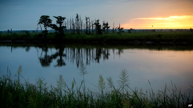
The sun rises on a "ghost forest" near the Savannah River in Port Wentworth, Ga. Rising sea levels are killing trees along vast swaths of the North American coast by inundating them in saltwater. The dead trees in what used to be thriving freshwater coastal environments are called “ghost forests” by researchers.
The report also said the global surface temperature observed was the highest on record last year, aided by the strong El Niño early in the year. The temperature of the region of the atmosphere just above the Earth's surface, known as the troposphere, was also the highest on record, as was the global average for the surface of the sea. Global sea level was also the highest on record, at 82 millimeters higher than the average in 1993, when records began to be recorded with the current method. The report said 2016 was the sixth consecutive year in which the global sea level increased compared with the previous year. The report also said a warming trend was continuing in the Arctic, and the Antarctic saw a new record low in the extent of sea ice coverage.
Story on draft report
The report came out just days after The New York Times published a draft U.S. government report on climate, which said that the average temperature in the United States had risen rapidly and drastically since 1980, and that recent decades had been the warmest in the past 1,500 years. The draft report was compiled by scientists at 13 federal agencies and concluded that Americans were already starting to feel the result of climate change, despite expectations that the change would not be felt for several more decades. The draft report directly contradicted claims by the Trump administration that the contribution of human activity to climate change is uncertain and unpredictable.
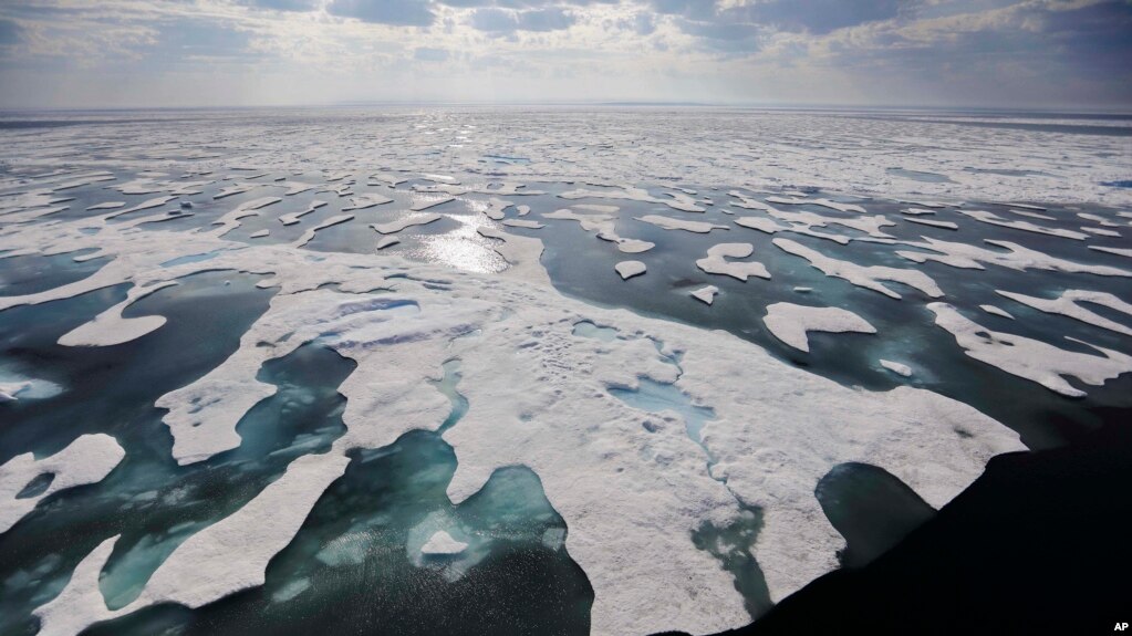
Sea ice melts on the Franklin Strait along the Northwest Passage in the Canadian Arctic Archipelago, July 22, 2017. Because of climate change, more sea ice is being lost each summer than is being replenished in winters. Less sea ice coverage also means that less sunlight will be reflected off the surface of the ocean in a process known as the albedo effect. The oceans will absorb more heat, further fueling global warming.
The report was leaked online in January but received little notice until the Times published the findings this week. Scientists have expressed fear that the Trump administration might try to suppress the findings since they contradict the stated positions of top U.S. officials, including Scott Pruitt, administrator of the U.S. Environmental Protection Agency. Pruitt has said repeatedly that he does not believe human activity plays a large role in climate change. The authors of the leaked study disagree with that stance, writing in the report: "Many lines of evidence demonstrate that human activities, especially emissions of greenhouse gases, are primarily responsible for recent observed climate change." That report is a special section of the National Climate Assessment and is published every four years. The National Academy of Sciences has approved the study, and authors are now waiting on the Trump administration to give the approval for its release.
Global Study Says 2016 Was Warmest Year on Record
My what a dumb ass you remain, Mr. Westwall. You really think that we cannot tell the difference between river erosion, and that caused by sea level rise and permafrost thaw?Yes, erosion caused by sea level rise and thawing permafrost. You are such a dumb ass.It's called erosion. Look it up fool.
You didn't read the link either dumb ass. Read the link I provided and learn something.
Paul Laustsen and Ann Gibbs
July–Sept. 2015
in this issue:
next story
In a new study published July 2015, scientists from the U.S. Geological Survey (USGS) found that the remote northern Alaska coast has some of the highest shoreline-erosion rates in the nation. Analyzing more than half a century of shoreline-change data, scientists discovered that the pattern is extremely variable, with most of the coast retreating at rates of more than 1 meter per year.
Above: Shaded-relief map of the north coast of Alaska showing study area (U.S.-Canadian border to Icy Cape; rectangular box) and selected geographic locations. Modified from figure 1 of "National Assessment of Shoreline Change: Historical Shoreline Change Along the North Coast of Alaska, U.S.-Canadian Border to Icy Cape." [larger version]
"Coastal erosion along the Arctic coast of Alaska is threatening Native Alaskan villages, sensitive ecosystems, energy- and defense-related infrastructure, and large tracts of Native Alaskan, State, and Federally managed land," said Suzette Kimball, acting director of the USGS.
Scientists studied more than 1,600 kilometers of the Alaskan coast between the U.S.-Canadian border and Icy Cape, Alaska, and found that the average rate of shoreline change, taking into account beaches that are both eroding and expanding, was a loss of 1.4 meters per year. Of those beaches that are eroding, the most extreme case exceeded 18.6 meters per year.
Above: North coast of Alaska study area showing color-coded shoreline-change rates, boundaries of the 10 analysis regions (dashed boxes and numbers) used in the study, and key geographic locations. Figure 72 in "National Assessment of Shoreline Change: Historical Shoreline Change Along the North Coast of Alaska, U.S.-Canadian Border to Icy Cape." [larger version]
"This report provides invaluable objective data to help Native communities, scientists, and land managers understand natural changes and human impacts on the Alaskan coast," said Ann Gibbs, USGS geologist and lead author of the new report.
Coastlines change in response to a variety of factors, including changes in the amount of available sediment, storm impacts, sea-level rise, and human activities. How much a coast erodes or expands in any given location is due to some combination of these factors, which vary from place to place.
Northern Alaska Coastal Erosion Threatens Habitat and Infrastructure
And I can give you many more articles from scientific sources saying exactly the same thing.
Indeed they do, and the records go back over thirty years, and the rate of erosion now, is no different from what it was back then. Which blows your assertion right out of the water.My what a dumb ass you remain, Mr. Westwall. You really think that we cannot tell the difference between river erosion, and that caused by sea level rise and permafrost thaw?Yes, erosion caused by sea level rise and thawing permafrost. You are such a dumb ass.It's called erosion. Look it up fool.
You didn't read the link either dumb ass. Read the link I provided and learn something.
Paul Laustsen and Ann Gibbs
July–Sept. 2015
in this issue:
next story
In a new study published July 2015, scientists from the U.S. Geological Survey (USGS) found that the remote northern Alaska coast has some of the highest shoreline-erosion rates in the nation. Analyzing more than half a century of shoreline-change data, scientists discovered that the pattern is extremely variable, with most of the coast retreating at rates of more than 1 meter per year.
Above: Shaded-relief map of the north coast of Alaska showing study area (U.S.-Canadian border to Icy Cape; rectangular box) and selected geographic locations. Modified from figure 1 of "National Assessment of Shoreline Change: Historical Shoreline Change Along the North Coast of Alaska, U.S.-Canadian Border to Icy Cape." [larger version]
"Coastal erosion along the Arctic coast of Alaska is threatening Native Alaskan villages, sensitive ecosystems, energy- and defense-related infrastructure, and large tracts of Native Alaskan, State, and Federally managed land," said Suzette Kimball, acting director of the USGS.
Scientists studied more than 1,600 kilometers of the Alaskan coast between the U.S.-Canadian border and Icy Cape, Alaska, and found that the average rate of shoreline change, taking into account beaches that are both eroding and expanding, was a loss of 1.4 meters per year. Of those beaches that are eroding, the most extreme case exceeded 18.6 meters per year.
Above: North coast of Alaska study area showing color-coded shoreline-change rates, boundaries of the 10 analysis regions (dashed boxes and numbers) used in the study, and key geographic locations. Figure 72 in "National Assessment of Shoreline Change: Historical Shoreline Change Along the North Coast of Alaska, U.S.-Canadian Border to Icy Cape." [larger version]
"This report provides invaluable objective data to help Native communities, scientists, and land managers understand natural changes and human impacts on the Alaskan coast," said Ann Gibbs, USGS geologist and lead author of the new report.
Coastlines change in response to a variety of factors, including changes in the amount of available sediment, storm impacts, sea-level rise, and human activities. How much a coast erodes or expands in any given location is due to some combination of these factors, which vary from place to place.
Northern Alaska Coastal Erosion Threatens Habitat and Infrastructure
And I can give you many more articles from scientific sources saying exactly the same thing.
Indeed they do, and the records go back over thirty years, and the rate of erosion now, is no different from what it was back then. Which blows your assertion right out of the water.
[paste:font size="5"]Catherine Puckett, Helen Gibbons, Benjamin Jones, and Maria-Jose Viñas (American Geophysical Union)
May 2009
in this issue:
The rate of coastal erosion more than doubled in Alaska—to as much as 45 feet per year—within the 52-year period between 1955 and 2007 along a 37-mile stretch of the Beaufort Sea, with ice-rich coastal bluffs showing the greatest increase in recent erosion rates.
A study led by the U.S. Geological Survey (USGS) Alaska Science Center reveals that average annual erosion rates along this part of the Beaufort Sea—north of a large lake named Teshekpuk and about 100 mi west-northwest of Prudhoe Bay—climbed from historical levels of about 20 feet per year between the mid-1950s and late-1970s, to 28 feet per year between the late-1970s and early 2000s, to 45 feet per year between 2002 and 2007. The authors also observed that spatial patterns of erosion have become more uniform across shorelines with different degrees of ice richness. Until 2002, erosion rates were highest on shorelines with relatively low ground-ice content; but from 2002 to 2007, the greatest increase in erosion rates occurred for ice-rich terrain, suggesting a fundamental shift in the dominant processes driving and resisting erosion. The study was published in Geophysical Research Letters, a publication of the American Geophysical Union.

Above left: USGS researcher Benjamin Jones measures erosion along part of Alaska’s Arctic coast. On left is an example of a collapsed block of ice-rich permafrost. Photograph by Christopher Arp, USGS. [larger version]
Above right: Ice-rich bluff photographed in early September 2007, during a period of mild, persistent easterly winds. Despite the absence of westerly storms, traditionally believed to drive coastal erosion in this region, waves were undermining the bluff at this time, as shown in the video clip (55 MB). (You will need the QuickTime Player to view the video.) Photograph by Christopher Arp; video by Benjamin Jones. [larger version]
The authors propose that the shifts in the rate and pattern of land loss along this segment of coastline are likely the result of changing Arctic conditions, including declining sea-ice extent, increasing summertime sea-surface temperature, rising sea level, and increases in storm power and corresponding wave action.
Erosion Doubles Along Part of Alaskas Arctic Coast - Cultural and Historical Sites Lost
Really Mr. Westwall, do you think you can actually get away with such outright lies? And do you think that anyone in their right mind would take your maundering over the research of the USGS?
My what a dumb ass you remain, Mr. Westwall. You really think that we cannot tell the difference between river erosion, and that caused by sea level rise and permafrost thaw?Yes, erosion caused by sea level rise and thawing permafrost. You are such a dumb ass.It's called erosion. Look it up fool.
You didn't read the link either dumb ass. Read the link I provided and learn something.
Paul Laustsen and Ann Gibbs
July–Sept. 2015
in this issue:
next story
In a new study published July 2015, scientists from the U.S. Geological Survey (USGS) found that the remote northern Alaska coast has some of the highest shoreline-erosion rates in the nation. Analyzing more than half a century of shoreline-change data, scientists discovered that the pattern is extremely variable, with most of the coast retreating at rates of more than 1 meter per year.
Above: Shaded-relief map of the north coast of Alaska showing study area (U.S.-Canadian border to Icy Cape; rectangular box) and selected geographic locations. Modified from figure 1 of "National Assessment of Shoreline Change: Historical Shoreline Change Along the North Coast of Alaska, U.S.-Canadian Border to Icy Cape." [larger version]
"Coastal erosion along the Arctic coast of Alaska is threatening Native Alaskan villages, sensitive ecosystems, energy- and defense-related infrastructure, and large tracts of Native Alaskan, State, and Federally managed land," said Suzette Kimball, acting director of the USGS.
Scientists studied more than 1,600 kilometers of the Alaskan coast between the U.S.-Canadian border and Icy Cape, Alaska, and found that the average rate of shoreline change, taking into account beaches that are both eroding and expanding, was a loss of 1.4 meters per year. Of those beaches that are eroding, the most extreme case exceeded 18.6 meters per year.
Above: North coast of Alaska study area showing color-coded shoreline-change rates, boundaries of the 10 analysis regions (dashed boxes and numbers) used in the study, and key geographic locations. Figure 72 in "National Assessment of Shoreline Change: Historical Shoreline Change Along the North Coast of Alaska, U.S.-Canadian Border to Icy Cape." [larger version]
"This report provides invaluable objective data to help Native communities, scientists, and land managers understand natural changes and human impacts on the Alaskan coast," said Ann Gibbs, USGS geologist and lead author of the new report.
Coastlines change in response to a variety of factors, including changes in the amount of available sediment, storm impacts, sea-level rise, and human activities. How much a coast erodes or expands in any given location is due to some combination of these factors, which vary from place to place.
Northern Alaska Coastal Erosion Threatens Habitat and Infrastructure
And I can give you many more articles from scientific sources saying exactly the same thing.
Indeed they do, and the records go back over thirty years, and the rate of erosion now, is no different from what it was back then. Which blows your assertion right out of the water.
30 years ago? Exxon Knew about Climate Change Almost 40 Years Ago
Once again, you are in denial.
My what a dumb ass you remain, Mr. Westwall. You really think that we cannot tell the difference between river erosion, and that caused by sea level rise and permafrost thaw?Yes, erosion caused by sea level rise and thawing permafrost. You are such a dumb ass.
You didn't read the link either dumb ass. Read the link I provided and learn something.
Paul Laustsen and Ann Gibbs
July–Sept. 2015
in this issue:
next story
In a new study published July 2015, scientists from the U.S. Geological Survey (USGS) found that the remote northern Alaska coast has some of the highest shoreline-erosion rates in the nation. Analyzing more than half a century of shoreline-change data, scientists discovered that the pattern is extremely variable, with most of the coast retreating at rates of more than 1 meter per year.
Above: Shaded-relief map of the north coast of Alaska showing study area (U.S.-Canadian border to Icy Cape; rectangular box) and selected geographic locations. Modified from figure 1 of "National Assessment of Shoreline Change: Historical Shoreline Change Along the North Coast of Alaska, U.S.-Canadian Border to Icy Cape." [larger version]
"Coastal erosion along the Arctic coast of Alaska is threatening Native Alaskan villages, sensitive ecosystems, energy- and defense-related infrastructure, and large tracts of Native Alaskan, State, and Federally managed land," said Suzette Kimball, acting director of the USGS.
Scientists studied more than 1,600 kilometers of the Alaskan coast between the U.S.-Canadian border and Icy Cape, Alaska, and found that the average rate of shoreline change, taking into account beaches that are both eroding and expanding, was a loss of 1.4 meters per year. Of those beaches that are eroding, the most extreme case exceeded 18.6 meters per year.
Above: North coast of Alaska study area showing color-coded shoreline-change rates, boundaries of the 10 analysis regions (dashed boxes and numbers) used in the study, and key geographic locations. Figure 72 in "National Assessment of Shoreline Change: Historical Shoreline Change Along the North Coast of Alaska, U.S.-Canadian Border to Icy Cape." [larger version]
"This report provides invaluable objective data to help Native communities, scientists, and land managers understand natural changes and human impacts on the Alaskan coast," said Ann Gibbs, USGS geologist and lead author of the new report.
Coastlines change in response to a variety of factors, including changes in the amount of available sediment, storm impacts, sea-level rise, and human activities. How much a coast erodes or expands in any given location is due to some combination of these factors, which vary from place to place.
Northern Alaska Coastal Erosion Threatens Habitat and Infrastructure
And I can give you many more articles from scientific sources saying exactly the same thing.
Indeed they do, and the records go back over thirty years, and the rate of erosion now, is no different from what it was back then. Which blows your assertion right out of the water.
30 years ago? Exxon Knew about Climate Change Almost 40 Years Ago
Once again, you are in denial.
The whole world has known about climate change for centuries, dummy. The climate is ALWAYS changing. It has ALWAYS changed, and it will ALWAYS be changing. It is only in the minds of infants that climate never changes.
My what a dumb ass you remain, Mr. Westwall. You really think that we cannot tell the difference between river erosion, and that caused by sea level rise and permafrost thaw?You didn't read the link either dumb ass. Read the link I provided and learn something.
Paul Laustsen and Ann Gibbs
July–Sept. 2015
in this issue:
next story
In a new study published July 2015, scientists from the U.S. Geological Survey (USGS) found that the remote northern Alaska coast has some of the highest shoreline-erosion rates in the nation. Analyzing more than half a century of shoreline-change data, scientists discovered that the pattern is extremely variable, with most of the coast retreating at rates of more than 1 meter per year.
Above: Shaded-relief map of the north coast of Alaska showing study area (U.S.-Canadian border to Icy Cape; rectangular box) and selected geographic locations. Modified from figure 1 of "National Assessment of Shoreline Change: Historical Shoreline Change Along the North Coast of Alaska, U.S.-Canadian Border to Icy Cape." [larger version]
"Coastal erosion along the Arctic coast of Alaska is threatening Native Alaskan villages, sensitive ecosystems, energy- and defense-related infrastructure, and large tracts of Native Alaskan, State, and Federally managed land," said Suzette Kimball, acting director of the USGS.
Scientists studied more than 1,600 kilometers of the Alaskan coast between the U.S.-Canadian border and Icy Cape, Alaska, and found that the average rate of shoreline change, taking into account beaches that are both eroding and expanding, was a loss of 1.4 meters per year. Of those beaches that are eroding, the most extreme case exceeded 18.6 meters per year.
Above: North coast of Alaska study area showing color-coded shoreline-change rates, boundaries of the 10 analysis regions (dashed boxes and numbers) used in the study, and key geographic locations. Figure 72 in "National Assessment of Shoreline Change: Historical Shoreline Change Along the North Coast of Alaska, U.S.-Canadian Border to Icy Cape." [larger version]
"This report provides invaluable objective data to help Native communities, scientists, and land managers understand natural changes and human impacts on the Alaskan coast," said Ann Gibbs, USGS geologist and lead author of the new report.
Coastlines change in response to a variety of factors, including changes in the amount of available sediment, storm impacts, sea-level rise, and human activities. How much a coast erodes or expands in any given location is due to some combination of these factors, which vary from place to place.
Northern Alaska Coastal Erosion Threatens Habitat and Infrastructure
And I can give you many more articles from scientific sources saying exactly the same thing.
Indeed they do, and the records go back over thirty years, and the rate of erosion now, is no different from what it was back then. Which blows your assertion right out of the water.
30 years ago? Exxon Knew about Climate Change Almost 40 Years Ago
Once again, you are in denial.
The whole world has known about climate change for centuries, dummy. The climate is ALWAYS changing. It has ALWAYS changed, and it will ALWAYS be changing. It is only in the minds of infants that climate never changes.
Don't you worry your pretty little head about it, the human race will die out before the next ice age, either from bugs causing viral and bacteria epidemics , lack of safe drinking water, polluted land, nuclear war, nature will take care of itself.
The hope was to postpone it as much as possible and have clean water, air and land. Everyone is going to die, but the human race doesn't have to, but the way we are going it will sooner than later.
Maybe a tribe will be left to reproduce, who knows.
Our beloved Pres. Trump isn't racist against anybody.You can't possibly believe he is not.
If you are anything like your avi and screen name, he's racist against you as well.
He is the best president the country has had in decades. .....
A village called "Teller" is eroding.
It was eroding some 30 years ago, especially when a big storm hit.
Gubbmint money flooded in for a relocation.
Bureaucrats built a slew of new houses on side of a protected lagoon.
They called it "New Site".
But few people moved there.
There was no store and no easy access to the water (hillside, remember?)
The bureaucrats smugly went home.
They knew they had "done good".
In less than 5 years the new houses were deteriorated.
About as close to "instant slum" as government has yet concocted.
The huge majority continued to live in the old houses, still at risk from the sea.
A new generation of bureaucrats rushed in to build more new houses. This
time at the original village site. Each with plumbing and neat porcelain toilets. But no sewer connections. They built on the runway of what had been the airport - where supplies for
the (then) two village stores were flown in.
To compensate government built a spiffy new airport on high ground.
About two miles from the old and new villages.
One of the stores burned down and was not replaced so prices went up.
It's called "progress".
View attachment 143642
How government helps:
View attachment 143642 View attachment 143643
My what a dumb ass you remain, Mr. Westwall. You really think that we cannot tell the difference between river erosion, and that caused by sea level rise and permafrost thaw?Yes, erosion caused by sea level rise and thawing permafrost. You are such a dumb ass.
You didn't read the link either dumb ass. Read the link I provided and learn something.
Paul Laustsen and Ann Gibbs
July–Sept. 2015
in this issue:
next story
In a new study published July 2015, scientists from the U.S. Geological Survey (USGS) found that the remote northern Alaska coast has some of the highest shoreline-erosion rates in the nation. Analyzing more than half a century of shoreline-change data, scientists discovered that the pattern is extremely variable, with most of the coast retreating at rates of more than 1 meter per year.
Above: Shaded-relief map of the north coast of Alaska showing study area (U.S.-Canadian border to Icy Cape; rectangular box) and selected geographic locations. Modified from figure 1 of "National Assessment of Shoreline Change: Historical Shoreline Change Along the North Coast of Alaska, U.S.-Canadian Border to Icy Cape." [larger version]
"Coastal erosion along the Arctic coast of Alaska is threatening Native Alaskan villages, sensitive ecosystems, energy- and defense-related infrastructure, and large tracts of Native Alaskan, State, and Federally managed land," said Suzette Kimball, acting director of the USGS.
Scientists studied more than 1,600 kilometers of the Alaskan coast between the U.S.-Canadian border and Icy Cape, Alaska, and found that the average rate of shoreline change, taking into account beaches that are both eroding and expanding, was a loss of 1.4 meters per year. Of those beaches that are eroding, the most extreme case exceeded 18.6 meters per year.
Above: North coast of Alaska study area showing color-coded shoreline-change rates, boundaries of the 10 analysis regions (dashed boxes and numbers) used in the study, and key geographic locations. Figure 72 in "National Assessment of Shoreline Change: Historical Shoreline Change Along the North Coast of Alaska, U.S.-Canadian Border to Icy Cape." [larger version]
"This report provides invaluable objective data to help Native communities, scientists, and land managers understand natural changes and human impacts on the Alaskan coast," said Ann Gibbs, USGS geologist and lead author of the new report.
Coastlines change in response to a variety of factors, including changes in the amount of available sediment, storm impacts, sea-level rise, and human activities. How much a coast erodes or expands in any given location is due to some combination of these factors, which vary from place to place.
Northern Alaska Coastal Erosion Threatens Habitat and Infrastructure
And I can give you many more articles from scientific sources saying exactly the same thing.
Indeed they do, and the records go back over thirty years, and the rate of erosion now, is no different from what it was back then. Which blows your assertion right out of the water.
30 years ago? Exxon Knew about Climate Change Almost 40 Years Ago
Once again, you are in denial.
The whole world has known about climate change for centuries, dummy. The climate is ALWAYS changing. It has ALWAYS changed, and it will ALWAYS be changing. It is only in the minds of infants that climate never changes.
Oh, so now the story is changed. You are no longer saying there has been no acceleration. Well, yes, a lot is due to the conditions of the ground. The permafrost is melting because of global warming.My what a dumb ass you remain, Mr. Westwall. You really think that we cannot tell the difference between river erosion, and that caused by sea level rise and permafrost thaw?Yes, erosion caused by sea level rise and thawing permafrost. You are such a dumb ass.
You didn't read the link either dumb ass. Read the link I provided and learn something.
Paul Laustsen and Ann Gibbs
July–Sept. 2015
in this issue:
next story
In a new study published July 2015, scientists from the U.S. Geological Survey (USGS) found that the remote northern Alaska coast has some of the highest shoreline-erosion rates in the nation. Analyzing more than half a century of shoreline-change data, scientists discovered that the pattern is extremely variable, with most of the coast retreating at rates of more than 1 meter per year.
Above: Shaded-relief map of the north coast of Alaska showing study area (U.S.-Canadian border to Icy Cape; rectangular box) and selected geographic locations. Modified from figure 1 of "National Assessment of Shoreline Change: Historical Shoreline Change Along the North Coast of Alaska, U.S.-Canadian Border to Icy Cape." [larger version]
"Coastal erosion along the Arctic coast of Alaska is threatening Native Alaskan villages, sensitive ecosystems, energy- and defense-related infrastructure, and large tracts of Native Alaskan, State, and Federally managed land," said Suzette Kimball, acting director of the USGS.
Scientists studied more than 1,600 kilometers of the Alaskan coast between the U.S.-Canadian border and Icy Cape, Alaska, and found that the average rate of shoreline change, taking into account beaches that are both eroding and expanding, was a loss of 1.4 meters per year. Of those beaches that are eroding, the most extreme case exceeded 18.6 meters per year.
Above: North coast of Alaska study area showing color-coded shoreline-change rates, boundaries of the 10 analysis regions (dashed boxes and numbers) used in the study, and key geographic locations. Figure 72 in "National Assessment of Shoreline Change: Historical Shoreline Change Along the North Coast of Alaska, U.S.-Canadian Border to Icy Cape." [larger version]
"This report provides invaluable objective data to help Native communities, scientists, and land managers understand natural changes and human impacts on the Alaskan coast," said Ann Gibbs, USGS geologist and lead author of the new report.
Coastlines change in response to a variety of factors, including changes in the amount of available sediment, storm impacts, sea-level rise, and human activities. How much a coast erodes or expands in any given location is due to some combination of these factors, which vary from place to place.
Northern Alaska Coastal Erosion Threatens Habitat and Infrastructure
And I can give you many more articles from scientific sources saying exactly the same thing.
Indeed they do, and the records go back over thirty years, and the rate of erosion now, is no different from what it was back then. Which blows your assertion right out of the water.My what a dumb ass you remain, Mr. Westwall. You really think that we cannot tell the difference between river erosion, and that caused by sea level rise and permafrost thaw?Yes, erosion caused by sea level rise and thawing permafrost. You are such a dumb ass.
You didn't read the link either dumb ass. Read the link I provided and learn something.
Paul Laustsen and Ann Gibbs
July–Sept. 2015
in this issue:
next story
In a new study published July 2015, scientists from the U.S. Geological Survey (USGS) found that the remote northern Alaska coast has some of the highest shoreline-erosion rates in the nation. Analyzing more than half a century of shoreline-change data, scientists discovered that the pattern is extremely variable, with most of the coast retreating at rates of more than 1 meter per year.
Above: Shaded-relief map of the north coast of Alaska showing study area (U.S.-Canadian border to Icy Cape; rectangular box) and selected geographic locations. Modified from figure 1 of "National Assessment of Shoreline Change: Historical Shoreline Change Along the North Coast of Alaska, U.S.-Canadian Border to Icy Cape." [larger version]
"Coastal erosion along the Arctic coast of Alaska is threatening Native Alaskan villages, sensitive ecosystems, energy- and defense-related infrastructure, and large tracts of Native Alaskan, State, and Federally managed land," said Suzette Kimball, acting director of the USGS.
Scientists studied more than 1,600 kilometers of the Alaskan coast between the U.S.-Canadian border and Icy Cape, Alaska, and found that the average rate of shoreline change, taking into account beaches that are both eroding and expanding, was a loss of 1.4 meters per year. Of those beaches that are eroding, the most extreme case exceeded 18.6 meters per year.
Above: North coast of Alaska study area showing color-coded shoreline-change rates, boundaries of the 10 analysis regions (dashed boxes and numbers) used in the study, and key geographic locations. Figure 72 in "National Assessment of Shoreline Change: Historical Shoreline Change Along the North Coast of Alaska, U.S.-Canadian Border to Icy Cape." [larger version]
"This report provides invaluable objective data to help Native communities, scientists, and land managers understand natural changes and human impacts on the Alaskan coast," said Ann Gibbs, USGS geologist and lead author of the new report.
Coastlines change in response to a variety of factors, including changes in the amount of available sediment, storm impacts, sea-level rise, and human activities. How much a coast erodes or expands in any given location is due to some combination of these factors, which vary from place to place.
Northern Alaska Coastal Erosion Threatens Habitat and Infrastructure
And I can give you many more articles from scientific sources saying exactly the same thing.
Indeed they do, and the records go back over thirty years, and the rate of erosion now, is no different from what it was back then. Which blows your assertion right out of the water.
[paste:font size="5"]Catherine Puckett, Helen Gibbons, Benjamin Jones, and Maria-Jose Viñas (American Geophysical Union)
May 2009
in this issue:
The rate of coastal erosion more than doubled in Alaska—to as much as 45 feet per year—within the 52-year period between 1955 and 2007 along a 37-mile stretch of the Beaufort Sea, with ice-rich coastal bluffs showing the greatest increase in recent erosion rates.
A study led by the U.S. Geological Survey (USGS) Alaska Science Center reveals that average annual erosion rates along this part of the Beaufort Sea—north of a large lake named Teshekpuk and about 100 mi west-northwest of Prudhoe Bay—climbed from historical levels of about 20 feet per year between the mid-1950s and late-1970s, to 28 feet per year between the late-1970s and early 2000s, to 45 feet per year between 2002 and 2007. The authors also observed that spatial patterns of erosion have become more uniform across shorelines with different degrees of ice richness. Until 2002, erosion rates were highest on shorelines with relatively low ground-ice content; but from 2002 to 2007, the greatest increase in erosion rates occurred for ice-rich terrain, suggesting a fundamental shift in the dominant processes driving and resisting erosion. The study was published in Geophysical Research Letters, a publication of the American Geophysical Union.
Above left: USGS researcher Benjamin Jones measures erosion along part of Alaska’s Arctic coast. On left is an example of a collapsed block of ice-rich permafrost. Photograph by Christopher Arp, USGS. [larger version]
Above right: Ice-rich bluff photographed in early September 2007, during a period of mild, persistent easterly winds. Despite the absence of westerly storms, traditionally believed to drive coastal erosion in this region, waves were undermining the bluff at this time, as shown in the video clip (55 MB). (You will need the QuickTime Player to view the video.) Photograph by Christopher Arp; video by Benjamin Jones. [larger version]
The authors propose that the shifts in the rate and pattern of land loss along this segment of coastline are likely the result of changing Arctic conditions, including declining sea-ice extent, increasing summertime sea-surface temperature, rising sea level, and increases in storm power and corresponding wave action.
Erosion Doubles Along Part of Alaskas Arctic Coast - Cultural and Historical Sites Lost
Really Mr. Westwall, do you think you can actually get away with such outright lies? And do you think that anyone in their right mind would take your maundering over the research of the USGS?
And how much of that erosion is due to the conditions of the ground being eroded? They ignore all the actual, real meaningful data, and instead concentrate on that which we KNOW is immaterial.
Alaskan towns at risk from rising seas sound alarm as Trump pulls federal help
Communities in danger of falling into the sea say assistance from Washington has dried up: ‘It feels like a complete abdication of responsibility on climate change’
.. Alaskan towns at risk from rising seas sound alarm as Trump pulls federal helpThe US government’s withdrawal from dealing with, or even acknowledging, climate change may have provoked widespread opprobrium, but for Alaskan communities at risk of toppling into the sea, the risks are rather more personal.
The Trump administration has moved to dismantle climate adaptation programs including the Denali Commission, an Anchorage-based agency that is crafting a plan to safeguard or relocate dozens of towns at risk from rising sea levels, storms and the winnowing away of sea ice.
Federal assistance for these towns has been ponderous but could now grind to a halt, with even those working on the issue seemingly targeted by the administration. In July, Joel Clement, an interior department official who worked with Alaskan communities on climate adaptation, claimed he had been moved to a completely unrelated position because of the administration’s ideological hostility to the issue.
“We were getting down to the brass tacks of relocation [of towns at risk] and now work has just stopped,” Clement told the Guardian. He has lodged an official complaint over his reassignment.
“Without federal coordination from Washington DC, there isn’t much hope. This will take millions of dollars and will take years, and these people don’t have years. I think it’s clear I was moved because of my climate work. It feels like a complete abdication of responsibility on climate change.”
According to the Army Corps of Engineers, 31 Alaskan communities face “imminent” existential threats from coastline erosion, flooding and other consequences of temperatures that are rising twice as quickly in the state as the global average. A handful – Kivalina, Newtok, Shishmaref and Shaktoolik – are considered in particularly perilous positions and will need to be moved. .
Our government is blind to reality.
So his attorneys are no experts on climate change?That is why T built a seawall in Ireland to protect his golf course of which his attorneys said it was needed due to global warming.
The Pubs are in denial about a lot.
How did a rise in the sea level cause the banks of the river to erode?Yes, erosion caused by sea level rise and thawing permafrost. You are such a dumb ass.It's called erosion. Look it up fool.

