Navigation
Install the app
How to install the app on iOS
Follow along with the video below to see how to install our site as a web app on your home screen.
Note: This feature may not be available in some browsers.
More options
You are using an out of date browser. It may not display this or other websites correctly.
You should upgrade or use an alternative browser.
You should upgrade or use an alternative browser.
More record temps
- Thread starter Chris
- Start date
RollingThunder
Gold Member
- Mar 22, 2010
- 4,818
- 525
- 155
Did you know that the Koch brothers are funders of BEST too? No, I didn't think so. Poor junior. Reduced to juvenile insults to try and feel good about yourself. When you grow up you can come back.
Oh walleyed, you poor retarded dingbat. Reduced to obscure, meaningless claims to defend your debunked nonsense. When you grow a brain, you can come back.
Nahh, I actually present cogent arguments. You on the other hand hurl insults like a petulant child. My turds have more brain power then you ever will junior.
I've always suspected that you were using turds instead of brains to formulate your arguments ('cause it's so obvious from your braindead posts) but thanks for confirming it, walleyed..... LOLOLOLOLOL......you poor deluded retard.

Attachments
RollingThunder
Gold Member
- Mar 22, 2010
- 4,818
- 525
- 155
Nahh, I actually present cogent arguments. You on the other hand hurl insults like a petulant child. My turds have more brain power then you ever will junior.
I've always suspected that you were using turds instead of brains to formulate your arguments ('cause it's so obvious from your braindead posts) but thanks for confirming it, walleyed..... LOLOLOLOLOL......you poor deluded retard.

Lead (sea ice)
From Wikipedia, the free encyclopedia
Leads are stretches of open water within fields of sea ice.[1] Leads are caused by movements of the ice due to wind, or to currents in the underlying water, and may open and close again within a brief period; alternatively they may remain open more or less permanently. The so-called "Big Lead", off the North Greenland coast, was discovered in 1906 by Robert Peary on his first (unsuccessful) North Polar trek, and was still there when he made his second attempt in 1909.
Notice carefully the last item in this encyclopedia entry.
Polynya
From Wikipedia, the free encyclopedia
A polynya (common US spelling) or polynia (common UK spelling) (pronounced /pəˈlɪnjə/) is an area of open water surrounded by sea ice.[1] It is now used as geographical term for areas of sea in Arctic or Antarctic regions which remain unfrozen for much of the year. It is a loanword from Russian: полынья, Russian pronunciation: [pəlɨˈnʲja] (polynya or polynia), which means a natural ice hole, and was adopted in the 19th century by polar explorers to describe navigable portions of the sea.[2][3] In past decades, for example, some polynyas, such as the Weddell Polynya, have lasted over multiple winters (19741976).[4]
Contents
* 1 Formation
* 2 Ecology
* 3 Arctic navigation
Formation
Polynyas are formed through two main processes:
* The first mechanism for polynya formation is thermodynamically driven, and occurs when the surface water temperature never reaches the freezing point. This may be due to a region of warm water upwelling, which reduces ice production and may stop it altogether. This type of polynya is called a Sensible Heat Polynya.
* The second type of polynya is called a Latent Heat Polynya and is formed through the action of katabatic wind or ocean currents which act to drive ice away from a fixed boundary, such as a coastline, fast ice, or an ice bridge. The polynya forms initially by the first year pack ice being driven away from the coast, which leaves an area of open water within which new ice is formed. This new ice is then also herded downwind toward the first year pack ice. When it reaches the pack ice the new ice is consolidated onto the first year pack ice. The latent heat polynya is the open water region between the coast and the first year ice pack.
Latent heat polynyas are regions of high ice production and therefore are possible sites of dense water production in both polar regions. The high ice production rates within these polynyas leads to a large amount of brine rejection into the surface waters. This salty water then sinks and mixes to possibly form new water masses. It is an open question as to whether the polynyas of the Arctic can produce enough dense water to form a major portion of the dense water required to drive the thermohaline circulation.
Arctic navigation
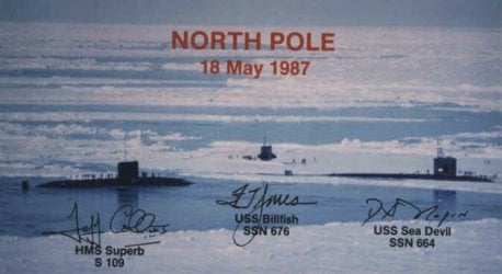
When submarines of the U.S. Navy made expeditions to the North Pole in the 1950s and 60s, there was a significant concern about surfacing through the thick pack ice of the Arctic Ocean. In 1962, both the USS Skate and USS Seadragon surfaced within the same, large polynya near the North Pole, for the first polar rendezvous of the U.S. Atlantic Fleet and the U.S. Pacific Fleet.[6]
***
Last edited:
RollingThunder
Gold Member
- Mar 22, 2010
- 4,818
- 525
- 155
When will this poor deluded rag of a thread finally get dragged into the Romper Room where it fucking belongs?
When will your pathetic excuse for a brain finally get dragged into the septic tank where it fucking belongs?
gslack
Senior Member
- Mar 26, 2010
- 4,527
- 356
- 48
I've always suspected that you were using turds instead of brains to formulate your arguments ('cause it's so obvious from your braindead posts) but thanks for confirming it, walleyed..... LOLOLOLOLOL......you poor deluded retard.
Lead (sea ice)
From Wikipedia, the free encyclopedia
Leads are stretches of open water within fields of sea ice.[1] Leads are caused by movements of the ice due to wind, or to currents in the underlying water, and may open and close again within a brief period; alternatively they may remain open more or less permanently. The so-called "Big Lead", off the North Greenland coast, was discovered in 1906 by Robert Peary on his first (unsuccessful) North Polar trek, and was still there when he made his second attempt in 1909.
Notice carefully the last item in this encyclopedia entry.
Polynya
From Wikipedia, the free encyclopedia
A polynya (common US spelling) or polynia (common UK spelling) (pronounced /pəˈlɪnjə/) is an area of open water surrounded by sea ice.[1] It is now used as geographical term for areas of sea in Arctic or Antarctic regions which remain unfrozen for much of the year. It is a loanword from Russian: полынья, Russian pronunciation: [pəlɨˈnʲja] (polynya or polynia), which means a natural ice hole, and was adopted in the 19th century by polar explorers to describe navigable portions of the sea.[2][3] In past decades, for example, some polynyas, such as the Weddell Polynya, have lasted over multiple winters (19741976).[4]
Contents
* 1 Formation
* 2 Ecology
* 3 Arctic navigation
Formation
Polynyas are formed through two main processes:
* The first mechanism for polynya formation is thermodynamically driven, and occurs when the surface water temperature never reaches the freezing point. This may be due to a region of warm water upwelling, which reduces ice production and may stop it altogether. This type of polynya is called a Sensible Heat Polynya.
* The second type of polynya is called a Latent Heat Polynya and is formed through the action of katabatic wind or ocean currents which act to drive ice away from a fixed boundary, such as a coastline, fast ice, or an ice bridge. The polynya forms initially by the first year pack ice being driven away from the coast, which leaves an area of open water within which new ice is formed. This new ice is then also herded downwind toward the first year pack ice. When it reaches the pack ice the new ice is consolidated onto the first year pack ice. The latent heat polynya is the open water region between the coast and the first year ice pack.
Latent heat polynyas are regions of high ice production and therefore are possible sites of dense water production in both polar regions. The high ice production rates within these polynyas leads to a large amount of brine rejection into the surface waters. This salty water then sinks and mixes to possibly form new water masses. It is an open question as to whether the polynyas of the Arctic can produce enough dense water to form a major portion of the dense water required to drive the thermohaline circulation.
Arctic navigation
When submarines of the U.S. Navy made expeditions to the North Pole in the 1950s and 60s, there was a significant concern about surfacing through the thick pack ice of the Arctic Ocean. In 1962, both the USS Skate and USS Seadragon surfaced within the same, large polynya near the North Pole, for the first polar rendezvous of the U.S. Atlantic Fleet and the U.S. Pacific Fleet.[6]
***
Yes yes repeat the same things over and over to hide the fact it was already bashed to smithereens a page or two ago...
Posting bullshit already disproven again and again doesn't make it less bullshit..

Okay a serious question now... What else do you do but post AGW propaganda?
Lead (sea ice)
From Wikipedia, the free encyclopedia
Leads are stretches of open water within fields of sea ice.[1] Leads are caused by movements of the ice due to wind, or to currents in the underlying water, and may open and close again within a brief period; alternatively they may remain open more or less permanently. The so-called "Big Lead", off the North Greenland coast, was discovered in 1906 by Robert Peary on his first (unsuccessful) North Polar trek, and was still there when he made his second attempt in 1909.
Notice carefully the last item in this encyclopedia entry.
Polynya
From Wikipedia, the free encyclopedia
A polynya (common US spelling) or polynia (common UK spelling) (pronounced /pəˈlɪnjə/) is an area of open water surrounded by sea ice.[1] It is now used as geographical term for areas of sea in Arctic or Antarctic regions which remain unfrozen for much of the year. It is a loanword from Russian: полынья, Russian pronunciation: [pəlɨˈnʲja] (polynya or polynia), which means a natural ice hole, and was adopted in the 19th century by polar explorers to describe navigable portions of the sea.[2][3] In past decades, for example, some polynyas, such as the Weddell Polynya, have lasted over multiple winters (19741976).[4]
Contents
* 1 Formation
* 2 Ecology
* 3 Arctic navigation
Formation
Polynyas are formed through two main processes:
* The first mechanism for polynya formation is thermodynamically driven, and occurs when the surface water temperature never reaches the freezing point. This may be due to a region of warm water upwelling, which reduces ice production and may stop it altogether. This type of polynya is called a Sensible Heat Polynya.
* The second type of polynya is called a Latent Heat Polynya and is formed through the action of katabatic wind or ocean currents which act to drive ice away from a fixed boundary, such as a coastline, fast ice, or an ice bridge. The polynya forms initially by the first year pack ice being driven away from the coast, which leaves an area of open water within which new ice is formed. This new ice is then also herded downwind toward the first year pack ice. When it reaches the pack ice the new ice is consolidated onto the first year pack ice. The latent heat polynya is the open water region between the coast and the first year ice pack.
Latent heat polynyas are regions of high ice production and therefore are possible sites of dense water production in both polar regions. The high ice production rates within these polynyas leads to a large amount of brine rejection into the surface waters. This salty water then sinks and mixes to possibly form new water masses. It is an open question as to whether the polynyas of the Arctic can produce enough dense water to form a major portion of the dense water required to drive the thermohaline circulation.
Arctic navigation
When submarines of the U.S. Navy made expeditions to the North Pole in the 1950s and 60s, there was a significant concern about surfacing through the thick pack ice of the Arctic Ocean. In 1962, both the USS Skate and USS Seadragon surfaced within the same, large polynya near the North Pole, for the first polar rendezvous of the U.S. Atlantic Fleet and the U.S. Pacific Fleet.[6]
***
Yes yes repeat the same things over and over to hide the fact it was already bashed to smithereens a page or two ago...
Posting bullshit already disproven again and again doesn't make it less bullshit..
Okay a serious question now... What else do you do but post AGW propaganda?
They post nothing but discredited drivel of course!
gslack
Senior Member
- Mar 26, 2010
- 4,527
- 356
- 48
Lead (sea ice)
From Wikipedia, the free encyclopedia
Leads are stretches of open water within fields of sea ice.[1] Leads are caused by movements of the ice due to wind, or to currents in the underlying water, and may open and close again within a brief period; alternatively they may remain open more or less permanently. The so-called "Big Lead", off the North Greenland coast, was discovered in 1906 by Robert Peary on his first (unsuccessful) North Polar trek, and was still there when he made his second attempt in 1909.
Notice carefully the last item in this encyclopedia entry.
Polynya
From Wikipedia, the free encyclopedia
A polynya (common US spelling) or polynia (common UK spelling) (pronounced /pəˈlɪnjə/) is an area of open water surrounded by sea ice.[1] It is now used as geographical term for areas of sea in Arctic or Antarctic regions which remain unfrozen for much of the year. It is a loanword from Russian: полынья, Russian pronunciation: [pəlɨˈnʲja] (polynya or polynia), which means a natural ice hole, and was adopted in the 19th century by polar explorers to describe navigable portions of the sea.[2][3] In past decades, for example, some polynyas, such as the Weddell Polynya, have lasted over multiple winters (19741976).[4]
Contents
* 1 Formation
* 2 Ecology
* 3 Arctic navigation
Formation
Polynyas are formed through two main processes:
* The first mechanism for polynya formation is thermodynamically driven, and occurs when the surface water temperature never reaches the freezing point. This may be due to a region of warm water upwelling, which reduces ice production and may stop it altogether. This type of polynya is called a Sensible Heat Polynya.
* The second type of polynya is called a Latent Heat Polynya and is formed through the action of katabatic wind or ocean currents which act to drive ice away from a fixed boundary, such as a coastline, fast ice, or an ice bridge. The polynya forms initially by the first year pack ice being driven away from the coast, which leaves an area of open water within which new ice is formed. This new ice is then also herded downwind toward the first year pack ice. When it reaches the pack ice the new ice is consolidated onto the first year pack ice. The latent heat polynya is the open water region between the coast and the first year ice pack.
Latent heat polynyas are regions of high ice production and therefore are possible sites of dense water production in both polar regions. The high ice production rates within these polynyas leads to a large amount of brine rejection into the surface waters. This salty water then sinks and mixes to possibly form new water masses. It is an open question as to whether the polynyas of the Arctic can produce enough dense water to form a major portion of the dense water required to drive the thermohaline circulation.
Arctic navigation
When submarines of the U.S. Navy made expeditions to the North Pole in the 1950s and 60s, there was a significant concern about surfacing through the thick pack ice of the Arctic Ocean. In 1962, both the USS Skate and USS Seadragon surfaced within the same, large polynya near the North Pole, for the first polar rendezvous of the U.S. Atlantic Fleet and the U.S. Pacific Fleet.[6]
***
Yes yes repeat the same things over and over to hide the fact it was already bashed to smithereens a page or two ago...
Posting bullshit already disproven again and again doesn't make it less bullshit..
Okay a serious question now... What else do you do but post AGW propaganda?
They post nothing but discredited drivel of course!
I think he just needs a hug....
Hugs are definately underated.
gslack
Senior Member
- Mar 26, 2010
- 4,527
- 356
- 48
They post nothing but discredited drivel of course!
I think he just needs a hug....
Hugs are definately underated.
Well I'm not gonna hug him... And pretty sure not gonna either.... I know KORNHOLEV will do it! Oh yeah he will hug the shit out of him...
Well I'm not gonna hug him... And pretty sure not gonna either.... I know KORNHOLEV will do it! Oh yeah he will hug the shit out of him...
Well they are very special friends you know!
gslack
Senior Member
- Mar 26, 2010
- 4,527
- 356
- 48
Hugs are definately underated.
Well I'm not gonna hug him... And pretty sure not gonna either.... I know KORNHOLEV will do it! Oh yeah he will hug the shit out of him...
Well they are very special friends you know!
RollingThunder
Gold Member
- Mar 22, 2010
- 4,818
- 525
- 155
Only in your demented dreams, slackjawedidiot. I challenge you to point to exactly which post "bashed" anything to "smithereens", you retarded nitwit. The existence of polynyas in the Arctic ice cap due to wind and wave action is an established scientific fact, moron.
Lead (sea ice)
From Wikipedia, the free encyclopedia
Leads are stretches of open water within fields of sea ice.[1] Leads are caused by movements of the ice due to wind, or to currents in the underlying water, and may open and close again within a brief period; alternatively they may remain open more or less permanently. The so-called "Big Lead", off the North Greenland coast, was discovered in 1906 by Robert Peary on his first (unsuccessful) North Polar trek, and was still there when he made his second attempt in 1909.
Notice carefully the last item in this encyclopedia entry.
Polynya
From Wikipedia, the free encyclopedia
A polynya (common US spelling) or polynia (common UK spelling) (pronounced /pəˈlɪnjə/) is an area of open water surrounded by sea ice.[1] It is now used as geographical term for areas of sea in Arctic or Antarctic regions which remain unfrozen for much of the year. It is a loanword from Russian: полынья, Russian pronunciation: [pəlɨˈnʲja] (polynya or polynia), which means a natural ice hole, and was adopted in the 19th century by polar explorers to describe navigable portions of the sea.[2][3] In past decades, for example, some polynyas, such as the Weddell Polynya, have lasted over multiple winters (19741976).[4]
Contents
* 1 Formation
* 2 Ecology
* 3 Arctic navigation
Formation
Polynyas are formed through two main processes:
* The first mechanism for polynya formation is thermodynamically driven, and occurs when the surface water temperature never reaches the freezing point. This may be due to a region of warm water upwelling, which reduces ice production and may stop it altogether. This type of polynya is called a Sensible Heat Polynya.
* The second type of polynya is called a Latent Heat Polynya and is formed through the action of katabatic wind or ocean currents which act to drive ice away from a fixed boundary, such as a coastline, fast ice, or an ice bridge. The polynya forms initially by the first year pack ice being driven away from the coast, which leaves an area of open water within which new ice is formed. This new ice is then also herded downwind toward the first year pack ice. When it reaches the pack ice the new ice is consolidated onto the first year pack ice. The latent heat polynya is the open water region between the coast and the first year ice pack.
Latent heat polynyas are regions of high ice production and therefore are possible sites of dense water production in both polar regions. The high ice production rates within these polynyas leads to a large amount of brine rejection into the surface waters. This salty water then sinks and mixes to possibly form new water masses. It is an open question as to whether the polynyas of the Arctic can produce enough dense water to form a major portion of the dense water required to drive the thermohaline circulation.
Arctic navigation
When submarines of the U.S. Navy made expeditions to the North Pole in the 1950s and 60s, there was a significant concern about surfacing through the thick pack ice of the Arctic Ocean. In 1962, both the USS Skate and USS Seadragon surfaced within the same, large polynya near the North Pole, for the first polar rendezvous of the U.S. Atlantic Fleet and the U.S. Pacific Fleet.[6]
***
Yes yes repeat the same things over and over to hide the fact it was already bashed to smithereens a page or two ago...
Wise words that you and the walleyedretard should heed. Your willingness to make fools out of yourselves by repeatedly posting thoroughly debunked denier cult bullshit is hilarious but also very pathetic.Posting bullshit already disproven again and again doesn't make it less bullshit..
gslack
Senior Member
- Mar 26, 2010
- 4,527
- 356
- 48
Only in your demented dreams, slackjawedidiot. I challenge you to point to exactly which post "bashed" anything to "smithereens", you retarded nitwit. The existence of polynyas in the Arctic ice cap due to wind and wave action is an established scientific fact, moron.
Lead (sea ice)
From Wikipedia, the free encyclopedia
Leads are stretches of open water within fields of sea ice.[1] Leads are caused by movements of the ice due to wind, or to currents in the underlying water, and may open and close again within a brief period; alternatively they may remain open more or less permanently. The so-called "Big Lead", off the North Greenland coast, was discovered in 1906 by Robert Peary on his first (unsuccessful) North Polar trek, and was still there when he made his second attempt in 1909.
Notice carefully the last item in this encyclopedia entry.
Polynya
From Wikipedia, the free encyclopedia
A polynya (common US spelling) or polynia (common UK spelling) (pronounced /pəˈlɪnjə/) is an area of open water surrounded by sea ice.[1] It is now used as geographical term for areas of sea in Arctic or Antarctic regions which remain unfrozen for much of the year. It is a loanword from Russian: полынья, Russian pronunciation: [pəlɨˈnʲja] (polynya or polynia), which means a natural ice hole, and was adopted in the 19th century by polar explorers to describe navigable portions of the sea.[2][3] In past decades, for example, some polynyas, such as the Weddell Polynya, have lasted over multiple winters (19741976).[4]
Contents
* 1 Formation
* 2 Ecology
* 3 Arctic navigation
Formation
Polynyas are formed through two main processes:
* The first mechanism for polynya formation is thermodynamically driven, and occurs when the surface water temperature never reaches the freezing point. This may be due to a region of warm water upwelling, which reduces ice production and may stop it altogether. This type of polynya is called a Sensible Heat Polynya.
* The second type of polynya is called a Latent Heat Polynya and is formed through the action of katabatic wind or ocean currents which act to drive ice away from a fixed boundary, such as a coastline, fast ice, or an ice bridge. The polynya forms initially by the first year pack ice being driven away from the coast, which leaves an area of open water within which new ice is formed. This new ice is then also herded downwind toward the first year pack ice. When it reaches the pack ice the new ice is consolidated onto the first year pack ice. The latent heat polynya is the open water region between the coast and the first year ice pack.
Latent heat polynyas are regions of high ice production and therefore are possible sites of dense water production in both polar regions. The high ice production rates within these polynyas leads to a large amount of brine rejection into the surface waters. This salty water then sinks and mixes to possibly form new water masses. It is an open question as to whether the polynyas of the Arctic can produce enough dense water to form a major portion of the dense water required to drive the thermohaline circulation.
Arctic navigation
When submarines of the U.S. Navy made expeditions to the North Pole in the 1950s and 60s, there was a significant concern about surfacing through the thick pack ice of the Arctic Ocean. In 1962, both the USS Skate and USS Seadragon surfaced within the same, large polynya near the North Pole, for the first polar rendezvous of the U.S. Atlantic Fleet and the U.S. Pacific Fleet.[6]
***
Yes yes repeat the same things over and over to hide the fact it was already bashed to smithereens a page or two ago...
Wise words that you and the walleyedretard should heed. Your willingness to make fools out of yourselves by repeatedly posting thoroughly debunked denier cult bullshit is hilarious but also very pathetic.Posting bullshit already disproven again and again doesn't make it less bullshit..
So then you deny this was already posted and gone over before?
Oh please deny this so we can once again show you for the pathetic lying weasel you are..
Old Rocks
Diamond Member
Yep, posted and gone over. And showed what total lying idiots you and Walleyes are.
Flap yap all you care too. For all you have posted to support your case thus far is discredited political screeds from political sites. So show us something from real scientists that are currently doing research. You know, the people from AGU, the Royal Society, USGS, NOAA, NASA, or anyone with real scientific credentials. Hell, even the sceptic Dr. Roy Spencers site shows rapid warming. And everybodies data shows the rapid melting of the Arctic Ice.
All you fellows have is a political denial of reality.
Old Rocks
Diamond Member
Going over the rainfall records, many are doubling or more the previous records for the first week of August. And the highest minimum temps once again are showing a nighttime warming that exceeds that of the daytime warming. So the air is contains more water vapor, 24/7. And the Missouri and Mississippi are still in flood.
HAMweather Climate Center - Record Events for The Past Week - Continental US View
Record Events for Sun Jul 31, 2011 through Sat Aug 6, 2011
Total Records: 3393
Rainfall: 459
High Temperatures: 1303
Low Temperatures: 43
Lowest Max Temperatures: 63
Highest Min Temperatures: 1525
HAMweather Climate Center - Record Events for The Past Week - Continental US View
Record Events for Sun Jul 31, 2011 through Sat Aug 6, 2011
Total Records: 3393
Rainfall: 459
High Temperatures: 1303
Low Temperatures: 43
Lowest Max Temperatures: 63
Highest Min Temperatures: 1525
What a total buffoon you are, roxie. Go back to algorian religion, moron.Yep, posted and gone over. And showed what total lying idiots you and Walleyes are.
Flap yap all you care too. For all you have posted to support your case thus far is discredited political screeds from political sites. So show us something from real scientists that are currently doing research. You know, the people from AGU, the Royal Society, USGS, NOAA, NASA, or anyone with real scientific credentials. Hell, even the sceptic Dr. Roy Spencers site shows rapid warming. And everybodies data shows the rapid melting of the Arctic Ice.
All you fellows have is a political denial of reality.
Yep, posted and gone over. And showed what total lying idiots you and Walleyes are.
Flap yap all you care too. For all you have posted to support your case thus far is discredited political screeds from political sites. So show us something from real scientists that are currently doing research. You know, the people from AGU, the Royal Society, USGS, NOAA, NASA, or anyone with real scientific credentials. Hell, even the sceptic Dr. Roy Spencers site shows rapid warming. And everybodies data shows the rapid melting of the Arctic Ice.
All you fellows have is a political denial of reality.
Sure MENSA boy sure....
even if we have to redefine what the peer-review literature is
- Thread starter
- #740
Almost 9,000 daily records were broken or tied last month, including 2,755 highest maximum temperatures and 6,171 highest minimum temperatures (night-time records), reported the National Oceanic and Atmospheric Administration (NOAA).
NOAA indicated, however, that the tally of records collected so far is not complete more are expected to come in as station data from across the U.S. is forwarded to the National Climatic Data Center. It said the statistics reported on the its temperature map only include weather stations with real-time electronic reporting, which accounts for about two-thirds of the locations. Final numbers are expected to be made available later in August.
The above image plots how many times a heat record was broken or tied in a given location. Some cities reached daily high temperatures 19 out of the 31 days in the month. The largest concentration of these records occur in the southern Plains, Midwest, and Northeast U.S., which were gripped by a series of heat waves pushing heat indices well into the 100s (Fahrenheit) for many days at a time.
Record July Temperatures In US Documented In NOAA Map - Irish Weather Online
Similar threads
- Replies
- 32
- Views
- 372
- Replies
- 28
- Views
- 371
- Replies
- 14
- Views
- 289
Latest Discussions
- Replies
- 0
- Views
- 1
- Replies
- 25
- Views
- 862
- Replies
- 7
- Views
- 45
- Replies
- 140
- Views
- 479
Forum List
-
-
-
-
-
Political Satire 8619
-
-
-
-
-
-
-
-
-
-
-
-
-
-
-
-
-
-
-
ObamaCare 781
-
-
-
-
-
-
-
-
-
-
-
Member Usernotes 485
-
-
-
-
-
-
-
-
-
-