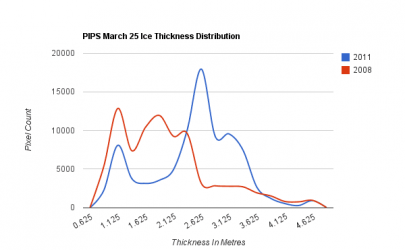
Arctic ice thins dramatically

Can't handle the truth at all, can you, BiPolar.

How did You get so screwed up?
You don`t even live in the real world any more and have become totally socially dysfunctional...You are not retired and claim in Your profile You are a millwright in Seattle...or did You change that recently..
and yet You sit all day long in front of Your PC and Google garbage for Your posts here.
I`m retired, yet I don`t just sit all day long in front of a PC and try find out about the WORLD from Google.
Sometimes though I don`t have anything better to do, like today for example...
Outside everything is still snow and ice...so my friends in Germany and I, e-mail each other little videos...
My plan for this afternoon was to "spring clean" the house...but then as it turned out my wife and Melvin`s wife (the cook from CFS Alert) had all that arranged already behind my back...
Now if You`ld "research" Canadian Indians on Google You get all sorts of crap...none of it matches up with REAL WORLD Indians, no more than what You Google regurgitate about Canada`s arctic...:
[ame="http://www.youtube.com/watch?v=fEyoKBgNVKc"]http://www.youtube.com/watch?v=fEyoKBgNVKc[/ame]

Fuck get off Your armchair and taste the real world, it`s not nearly as ugly as the Google picture You use as a substitute!
It`s the exact opposite


I`m not an expert and never have qualified as a judge in a beauty contest, but that`s what I believe
Come visit me some day, I won`t bite and neither would Cheyenne....My "all guests are welcome" picture below is for climate change "experts",...not the fools who believe them...but don`t forget to bring long johns, woolen socks and a parka

You probably "Google earthed" my back yard and will tell me I`m a liar, because it showed no snow and ice...
Well today was March 29...I don`t know what Google has You seeing in my yard, but the facts on the ground looked like this, "the truth I can`t handle" as You put it
[ame="http://www.youtube.com/watch?v=FbXxYzjuLY4"]http://www.youtube.com/watch?v=FbXxYzjuLY4[/ame]
Maybe You should get a "Google Earth account" with the CIA, they can zoom in a lot better in "real time mode"so You can keep a better eye on me and what REALLY goes on in my back yard
I`m trying all sorts of things to melt this shit in my yard...maybe they weren`t hot enough?
Could You handle my real world?
 
Last edited:
Polar bro......environmental k00ks like Old Rocks are literally romanced by living in the realm of idealist speculation. Think about any far left guy you know.........they reject ANY and ALL information if it confronts their ideology. It is the liberal mind. For nutballs like Chris and Old Rocks, your information is daunting to the point of seriously shaking the mental status..........such is their obsession. Tell me you cant see these people coming in the door after work, ripping off their coats and passing up a visit to the john to fire up their PC to get on here and defend their k00k position!!!! Its a mental disorder............but I must admit, I do gain much satisfaction in coming in here for a cup of coffee and decimating their shit. Torturing k00ks is definately a hobby for me.............publically humiliating those who navigate life with horse blinders on their face every day.......

Would love to see how long limpwristers like Chris and Old Rocks last in the environment you live in!!:D:up::boobies::funnyface:
 
Last edited:
At its peak this winter, Arctic Ocean ice covered the smallest area since satellites started measuring it in 1979, researchers report.

Arctic sea ice probably reached its maximum extent for the year on March 7, at 5.65 million square miles, according to the University of Colorado-Boulder’s National Snow and Ice Data Center.

That figure was 463,000 square miles (about the size of South Africa) less than the 1979-2000 average of 6.12 million square miles, and was about the same as in the winter of 2006, the center reported.

At its end-of-summer minimum in September, Arctic sea ice extent was the third-lowest since 1979.

Sea ice extent is the primary measure for assessing the condition of the ice cover, according to the National Oceanic and Atmospheric Administration.

The NOAA website has a time-lapse video showing how sea ice fluctuates and moves during winter.

“I’m not surprised by the new data because we’ve seen a downward trend in winter sea ice extent for some time now,” National Snow and Ice Data Center scientist Walt Meier told Science Daily.

The seven lowest measurements of end-of-winter sea ice have been recorded in the last seven years, he told Science Daily.

Arctic ice at winter peak is least ever measured by satellite – This Just In - CNN.com Blogs


Extent may be less but thickness is dramatically increasing. Also they claim lowest extent since 1979 but that seems to be untrue. Lowest extent I can find was 2007. This year was greater then that year. But the thickness is really amazing.
 

Attachments

  • $chart_110.png
    $chart_110.png
    6.8 KB · Views: 16
I'd love some of that fucking global warming right now in the Twin Cities, MN. I'm sick of the snow and ice we have down here and would like the women to stop wearing parkas for the first time since SEPTEMBER!!!

7th snowiest all time recorded, and although not the coldest, it won't fucking go away!
 
Arctic Ice March 2011

The image below, taken from the March 02 2011 NASA MODIS Arctic Mosaic, shows the state of the ice in Baffin Bay and nearby regions. From my historical researches, I would say that this is the sort of ice distribution that explorers in the 19th century might have considered fairly unremarkable - but at the end of July, not the beginning of March.
 
Would love to see how long limpwristers like Chris and Old Rocks last in the environment you live in!!:D:up::boobies::funnyface:

About 2 New York seconds.

I'd love some of that fucking global warming right now in the Twin Cities, MN. I'm sick of the snow and ice we have down here and would like the women to stop wearing parkas for the first time since SEPTEMBER!!!

7th snowiest all time recorded, and although not the coldest, it won't fucking go away!

Hey I sympathize, we go shopping there for some of the stuff they don`t stock in Manitoba. Where You live it`s not much "warmer" than where I live.
Were You hoping just like us, that You could trade in Your hockey stick for Golf clubs in the Spring ever since the "Hockey Stick Temp Graph" was published..Boy oh boy did they let us down. I bet You`ll be playing ice hockey almost as long as us guys in Manitoba.

At its peak this winter, Arctic Ocean ice covered the smallest area since satellites started measuring it in 1979, researchers report.

Arctic sea ice probably reached its maximum extent for the year on March 7, at 5.65 million square miles, according to the University of Colorado-Boulder’s National Snow and Ice Data Center.
...National Snow and Ice Data Center scientist Walt Meier told Science Daily.
....The seven lowest measurements of end-of-winter sea ice have been recorded in the last seven years, he told Science Daily.
Arctic ice at winter peak is least ever measured by satellite – This Just In - CNN.com Blogs

See, that`s exactly what I was talking about. An "expert" who who is watching satellite pictures, which focus on the Nares Strait, because that`s where the "Global Warming" fodder is...!!! But all the other NASA data which shows how the ice has been building up in other areas of Greenland does not interest him, nor CNN, nor the bloggers You quote..
Chris, don`t take their word as the gospel truth

Chris, there are several reasons why they focus on that area of Greenland, if You were to go there Yourself You would see right away why..It has the steepest slopes and therefore the highest calving action. Atmospheric temperature has nothing to do with it.
The water temperature all around this area has been constant also and always has been warmer than anywhere else in the arctic. I have to admit I have not been up there in 2011 but I doubt any of that has changed since I`ve been there
Taking water temperatures and salinity readings is part of our job up there, but I doubt that the Navy will publish this data, because it was meant for "sub-drivers" that navigate through there on the way to the Dock in Thule and then hide under the polar ice.
But this should help to calm You down...Your house will not get flooded by our "melting ice"..:
The surface waters of the North Atlantic have a higher salinity than those of any other ocean, reaching values exceeding 37 parts per thousand in latitudes
Near the Equator, precipitation dominates and surface salinities of about 35 parts per thousand are encountered
In all fairness I won`t leave this out, but like "OldRocks" I should have, because it does not fit "my oil lobby agenda"...:
At increasingly higher latitudes, precipitation again becomes greater than evaporation, and, correspondingly, the surface salinity decreases in large areas to values less than 34 parts per thousand.
That is only half true when You go as far North as where Greenland is. Because ..
1.) there hardly ever is any precipitation and if there is it comes down as snow and BUILDS up the Glaciers..it sure as hell does not rain very often there.
And...
2.) The SURFACE salinity at the SOUTHERN (Greenland) TIP ONLY is lower because of the glacier calving in that area...not because "it rains"
Take a look at the Atlantic ocean currents, they have not changed, but I think it might help you understand why that area of Greenland and Ellesmere Island is "warm"..:
image_full

What is missing in this picture is how the southern Greenland tip gouges into this current and the "eddie action" goes up half way the Nares Strait between Ellesmere and Greenland. After all there were reasons why the earliest arctic explorer vessels which were`nt "ice breakers" by any stretch of imagination navigated up the Nares as far as they could ride this warm water current..and got as far as Fort Conger way back in 1876. They were in striking distance to reach the North Pole, but that`s as far as they got, after that the climate on both sides of the Nares gets brutally cold and they all died right there
FortCongerMemorial.jpg

FortCongeronGround.jpg

The line where You get blocked by ice is today also exactly where it was back then in 1876. That`s all stuff You cant` see by satellite..like the huts where the crew of the HMS Discovery died, and the tree stumps of the forests that grew there who knows how many 1000`s of years ago.

Even if hell freezes over Michael Mann won`t write a blog about it.
SWOonfossilforest.jpg
Fossilstump1.jpg


I have yet to see a CNN report on Fort Conger, Tree Stumps near the pole etc etc..But they do "reports" on Iqaluit natives "having to eat @ McDonalds, instead of raw seal meat...because the ice is too thin"...
My God, has aside from us up there never seen seal on the shores?...Polarbears know,that seals don`t just hang out, way out the ice sheets...
they hang out where the fish they want to eat are!
And any starving Iqaluit native could shoot seal without getting off his couch, if he`d quit playing video games or watch TV...all You have to do is look out the window...We stop in Iqaluit almost every time on our way back from Ellesmere and Thule to AFB Trenton, when we get to go on 6 months leave.
I know what is going on in Iqaluit! You can trip over seal on solid land

California golden seal don`t need any ice...:
seals-on-the-beach.jpg

and neither do arctic seal, but they have it...
all along the shore there in Iqualuit...the seals hang out like that too, ice or no ice...and no matter if it`s a polar bear or an Eskimo, they could bag one any tme they wanted to
there are a lot polar bears which refuse to leave Churchill and go out on the ice...because they find it easier to eat in the Churchill dump...instead of hunting for food...Wild Life officers have to "dart" them and transport them by helicopter out on the ice sheet...
As You know that is problem with wildlife and especially with bears, they behave like that EVERYWHERE else too,...!
Coyotes, same thing. I had to be in L.A. for a while and then there was a problem with Coyotes in the back-lanes raiding garbage cans..
Nobody in LA said the Coyotes are doing this because "they are starving"
once they found a dump, You can`t get them away from it any more...same as trying to get Iqaluit Eskimos to stay away from McGreaseburgers, once they are in town
You don`t have to live in the arctic to know that...!
Nevertheless, the GW`ers got lots of mileage out of the "starving polar bears" and the "starving Inuit"
Use Your head Chris...I know You have one...Mathew used it
But it`s up to You which version You prefer about the Greenland glaciers and the Lincoln sea ice sheet
 
Last edited:
Thickness increasing? Really?

PIOMAS | Hot Topic

Somebody is full of shit.

CBC - Global Warming Doomsday Called Off

Canadians know a little bit more about their own climate, and their ice, than You or Your "experts" ever will
i know, I know, the CBC and the BBC does not count because we sell 60% of the oil the U.S. imports and the British have BP petroleum drilling off shore rigs along both U.S. coasts..that makes us CO2 conspirators in You weird world
 
Last edited:
At its peak this winter, Arctic Ocean ice covered the smallest area since satellites started measuring it in 1979, researchers report.

Arctic sea ice probably reached its maximum extent for the year on March 7, at 5.65 million square miles, according to the University of Colorado-Boulder’s National Snow and Ice Data Center.

That figure was 463,000 square miles (about the size of South Africa) less than the 1979-2000 average of 6.12 million square miles, and was about the same as in the winter of 2006, the center reported.

At its end-of-summer minimum in September, Arctic sea ice extent was the third-lowest since 1979.

Sea ice extent is the primary measure for assessing the condition of the ice cover, according to the National Oceanic and Atmospheric Administration.

The NOAA website has a time-lapse video showing how sea ice fluctuates and moves during winter.

“I’m not surprised by the new data because we’ve seen a downward trend in winter sea ice extent for some time now,” National Snow and Ice Data Center scientist Walt Meier told Science Daily.

The seven lowest measurements of end-of-winter sea ice have been recorded in the last seven years, he told Science Daily.

Arctic ice at winter peak is least ever measured by satellite – This Just In - CNN.com Blogs


This knucklehead sending me PMs "Your crap is growing tiresome". What a fcukking weenie..........

Meanwhile, how many times does somebody post up the same lame crap as this nutball?


Its the same shit all the time.


But my crap is growing tiresome!!!:funnyface::funnyface::coffee::boobies::funnyface::fu:


s0n.....you are one boring mofu. You need to join a glee club or something.......take the mind off of this mindless science crap nobody cares abut..........
 
Last edited:
Chris, I am not a pompous ass trying to impress You with how rigorous background
checks are before You get sec.clear. to serve at SAC Thule and at Milstar downlink
sites on Ellesmere, but they don`t hand these out to bullshitters!
So, trust me, I am not trying to bullshit You, I`m only trying to tell You what the real
facts on the ground are...You can`t find these with Google or cherry picked Satellite pictures.
[ame=http://www.youtube.com/watch?v=9ZiYkhw_7hU]YouTube - Global warming trees.wmv[/ame]
Anyhow, if You think I`m lying in this video here about the largest growth rings were
~ the time of Attila The Hun and then got smaller further out in these
trees which I showed to my friends from Germany ....I`ll ask them first if it`s Okay with
them...and `ll give You all 6 e-mail addresses,....

Everyone from Germany who`s been here and REALLY looked knows what kind of crap this M.Mann tree growth ring computer model temperature curve is...
I`d like to see Al Gore shit his pants if every time he unpacks a sandwich to have a
bite, bears come out of the woods and want Your sandwich...
as if a jerk who rides in bullet proof limos would ever venture out to see for himself.
A lot of other Americans would love too, but they are stuck at their place of employment
to feed the N.R.S. and they don`t have 6 Month vacation stretches like I did...
So I ventured out and I am happy to share this stuff with them...
So, when they do get some time off they know where to have the good times they
well deserved. You don`t have to hug trees to be one with nature You know..?
I know Westwall has been over a lot of the same country I have been and on one occasion both of us are pretty sure, I bumped into his college up at Muncho Lake/ Yukon Territories.
Fuck Disneyland...and "Google Earth" go out there into the REAL WORLD and
ENJOY IT...!!!
 
From the Geological Survey of Canada.

Permafrost - Permafrost and Climate Change

The Western NWT has experienced over the last century the greatest increase in air temperatures in all of Canada (1.7°C). Much of permafrost is at temperatures very close to the melting point of ice, and processes triggered by thawing ground ice are sensitive to warming, particularly where ice contents are high and the potential for soil instability upon thaw exists. The interaction between climate above and below the ground is complex, and dependent on several factors, many of which may also be affected by global change.

Much of the area of discontinuous permafrost is already in disequilibrium with the current climate and is still responding to changes of the last century. Permafrost is dynamic and will respond if climate continues to change as anticipated in the years and decades to come. The GSC has established a network of study sites in the Mackenzie Valley for monitoring the impact of climate change on ground temperatures and the active layer. This research will improve our understanding of permafrost-climate interaction and our capability to predict permafrost response to future climate change. However, it must be completed by a clearer understanding of how processes such as sediment transport in rivers, slope failure, and ground subsidence will also be affected by climate change. This understanding is necessary for the proper development and design of infrastructures in the North.

In response to concerns about the effects of global climate warming, the Mackenzie Valley is one of three regions selected for the GSC's "Integrated Research and Monitoring Area" (IRMA) program. The objective of this program is to identify regions of Canada with geologic conditions or processes especially sensitive to climate warming and to determine the response of these conditions and processes to this change. Specifically, the purpose of the Mackenzie IRMA is to reconstruct the climate since the end of the Laurentide Ice Age (~ 13,000 yrs. BP) based on the relationship between climate and vegetation, to produce maps of permafrost and ground ice distribution, and to determine the sensitivity of landscape-altering processes to climate warming. The Mackenzie Valley IRMA report is a synthesis of information about permafrost in the Mackenzie Valley.
 
Well now, it certainly looks like some Canadian Scientists are a bit worried about the warming of the Arctic.

Permafrost - Communities and Climate Change

1. Outlining infrastructure, surficial geology, and permafrost for two northern case study communities

This project compiled a summary of infrastructure and existing geotechnical and permafrost data for the selected northern communities, Norman Wells and Tuktoyaktuk. Infrastructure data includes foundation and construction type, maintenance history and performance. Surficial geology, geotechnical and permafrost conditions in each community are assessed through a survey of surficial deposits, borehole stratigraphy, geotechnical studies, ground ice and ground temperatures, primarily from existing data. A generic review of foundation problems related to permafrost was initiated in order to help identify and implement the most appropriate response strategies related to climate change impacts. This has resulted in the compilation of a summary report for each community outlining present infrastructure, surficial geology, and permafrost conditions.

The entire digital database and borehole viewers are published as GSC Open File 3912.

2. Assessment of the sensitivity of northern infrastructure to climate change impacts

This phase of the project attempted in a rational way to assess the sensitivity of permafrost-affected infrastructure to current climate trends and to future climate change scenarios. This utilized thermal modeling in combination with an evaluation of geotechnical data to assess the potential impact of thawing in both the continuous and discontinuous permafrost zones. The combination of permafrost modelling and geotechnical evaluation provided a methodological framework for assessing foundation performance and the potential for problematic ground conditions at the community level. This framework, building upon the screening process of Bush et al, (1998), provided the opportunity to expand research on infrastructure, permafrost and climate change scenarios to other northern communities.
 
More news from Canada.

Melting permafrost threatens Arctic housing projects - CTV News

Date: Sunday Jun. 20, 2010 12:52 PM ET

MONTREAL — An Arctic community that has seen its fire hall sink and roads buckle in the melting permafrost is now shifting future building projects away from town.

The effect of vanishing permafrost -- soil normally frozen year round -- is now being felt across Canada's North, and the Quebec village of Salluit is just one of many Arctic towns trying to adapt to an increasingly warmer climate.

Rising temperatures are being blamed for natural disturbances in the North, such as the rapidly eroding coastline of Tuktoyaktuk, N.W.T., and unprecedented floods that knocked out two bridges in Pangnirtung, Nunavut.

Salluit even considered relocating the whole town. One of Quebec's northernmost communities, Salluit saw its local fire station sink into the softening ground a year after it opened.

Across town, paved roads have crumpled, foundations of buildings have cracked and now even summertime grave-digging isn't what it used to be.

.................................................................................................................

He says the region has seen extreme weather patterns in the last decade -- including warmer summers and shorter winters that barely see temperatures dip below -30 C when they've been known in the past to hit -60 C with the windchill.

The brief winter last year shortened the window of opportunity for local hunters to reach caribou herds, impacting the local way of life.

"Salluit has had to order out for food from other communities that have (meat) because of the early thaw and late freeze-up," Okituk said of game shipments that arrived through a hunter-support program between northern communities.

"We enjoyed the good weather. (But) it was too long, because bad weather also brings in good stuff, too."
 
From the Geological Survey of Canada.

Permafrost - Permafrost and Climate Change

The Western NWT has experienced over the last century the greatest increase in air temperatures in all of Canada (1.7°C). Much of permafrost is at temperatures very close to the melting point of ice, and processes triggered by thawing ground ice are sensitive to warming, particularly where ice contents are high and the potential for soil instability upon thaw exists. The interaction between climate above and below the ground is complex, and dependent on several factors, many of which may also be affected by global change.

Much of the area of discontinuous permafrost is already in disequilibrium with the current climate and is still responding to changes of the last century. Permafrost is dynamic and will respond if climate continues to change as anticipated in the years and decades to come. The GSC has established a network of study sites in the Mackenzie Valley for monitoring the impact of climate change on ground temperatures and the active layer. This research will improve our understanding of permafrost-climate interaction and our capability to predict permafrost response to future climate change. However, it must be completed by a clearer understanding of how processes such as sediment transport in rivers, slope failure, and ground subsidence will also be affected by climate change. This understanding is necessary for the proper development and design of infrastructures in the North.

In response to concerns about the effects of global climate warming, the Mackenzie Valley is one of three regions selected for the GSC's "Integrated Research and Monitoring Area" (IRMA) program. The objective of this program is to identify regions of Canada with geologic conditions or processes especially sensitive to climate warming and to determine the response of these conditions and processes to this change. Specifically, the purpose of the Mackenzie IRMA is to reconstruct the climate since the end of the Laurentide Ice Age (~ 13,000 yrs. BP) based on the relationship between climate and vegetation, to produce maps of permafrost and ground ice distribution, and to determine the sensitivity of landscape-altering processes to climate warming. The Mackenzie Valley IRMA report is a synthesis of information about permafrost in the Mackenzie Valley.


Oh looky here another example of oltrakrfrauds wonderful sense of timliness! A 2007 update of a 1996 study Wow, oltrakarfraud is right on top of the current research there!:lol::lol::lol:
 
Well now, it certainly looks like some Canadian Scientists are a bit worried about the warming of the Arctic.

Permafrost - Communities and Climate Change

1. Outlining infrastructure, surficial geology, and permafrost for two northern case study communities

This project compiled a summary of infrastructure and existing geotechnical and permafrost data for the selected northern communities, Norman Wells and Tuktoyaktuk. Infrastructure data includes foundation and construction type, maintenance history and performance. Surficial geology, geotechnical and permafrost conditions in each community are assessed through a survey of surficial deposits, borehole stratigraphy, geotechnical studies, ground ice and ground temperatures, primarily from existing data. A generic review of foundation problems related to permafrost was initiated in order to help identify and implement the most appropriate response strategies related to climate change impacts. This has resulted in the compilation of a summary report for each community outlining present infrastructure, surficial geology, and permafrost conditions.

The entire digital database and borehole viewers are published as GSC Open File 3912.

2. Assessment of the sensitivity of northern infrastructure to climate change impacts

This phase of the project attempted in a rational way to assess the sensitivity of permafrost-affected infrastructure to current climate trends and to future climate change scenarios. This utilized thermal modeling in combination with an evaluation of geotechnical data to assess the potential impact of thawing in both the continuous and discontinuous permafrost zones. The combination of permafrost modelling and geotechnical evaluation provided a methodological framework for assessing foundation performance and the potential for problematic ground conditions at the community level. This framework, building upon the screening process of Bush et al, (1998), provided the opportunity to expand research on infrastructure, permafrost and climate change scenarios to other northern communities.


Oh looky here another example of oltrakrfrauds wonderful sense of timliness! A 2007 update of a 2000 study Wow, oltrakarfraud is right on top of the current research there!
 
More news from Canada.

Melting permafrost threatens Arctic housing projects - CTV News

Date: Sunday Jun. 20, 2010 12:52 PM ET

MONTREAL — An Arctic community that has seen its fire hall sink and roads buckle in the melting permafrost is now shifting future building projects away from town.

The effect of vanishing permafrost -- soil normally frozen year round -- is now being felt across Canada's North, and the Quebec village of Salluit is just one of many Arctic towns trying to adapt to an increasingly warmer climate.

Rising temperatures are being blamed for natural disturbances in the North, such as the rapidly eroding coastline of Tuktoyaktuk, N.W.T., and unprecedented floods that knocked out two bridges in Pangnirtung, Nunavut.

Salluit even considered relocating the whole town. One of Quebec's northernmost communities, Salluit saw its local fire station sink into the softening ground a year after it opened.

Across town, paved roads have crumpled, foundations of buildings have cracked and now even summertime grave-digging isn't what it used to be.

.................................................................................................................

He says the region has seen extreme weather patterns in the last decade -- including warmer summers and shorter winters that barely see temperatures dip below -30 C when they've been known in the past to hit -60 C with the windchill.

The brief winter last year shortened the window of opportunity for local hunters to reach caribou herds, impacting the local way of life.

"Salluit has had to order out for food from other communities that have (meat) because of the early thaw and late freeze-up," Okituk said of game shipments that arrived through a hunter-support program between northern communities.

"We enjoyed the good weather. (But) it was too long, because bad weather also brings in good stuff, too."


Finally a more current story, however they jump to a conclusion without bothering to check if maybe the fact the building they built on the permafrost was warm might have had an effect on the ice below....nah, that's too logical, we have to blame GW.
 

Forum List

Back
Top