Faun
Diamond Member
- Nov 14, 2011
- 123,612
- 79,105
These numbnuts make up whatever's convenient for them.LOL What a fool you are. You come here and state that you are an image expert and that the data from NASA is fake. Yet you give nothing to back that up with. Next you will be like Silly Billy and claiming that you are an atmospheric physicist, while posting drivel that indicates that you don't understand the simplest of physics.Yeah, almost the same.
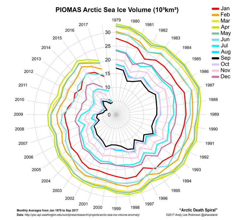
Sorry faun, but as an expert image analyst and image processor, I don't believe everything I see. Want me to tell you all about digital? Do you want to know how easily I can make that polar ice totally disappear, put it back as it was or even move the countries around to put Russia where Canada ought to be? Takes more than an internet posted exif-jpeg picture to convince me. Besides, so what if the ice did melt over a few years? As I pointed out earlier, what matters is LONG-TERM variation. 5 years from now, all that ice could be right back. Keep drinking the Koolaid.
If NASA is faking the data, how come the satellites from the EU, Japan, China, and Russia are seeing the same thing? And why would every Scientific Society, every National Academy of Science, and every major University all say that AGW is real, and a clear and present danger? Are you positing an international conspiracy involving millions of scientists? Is your little tin hat on a bit too tight?


 length(filenames)-1))