ReinyDays
Gold Member
That weather is statistical.
No ... folks who put money on this at 20 to 1 are gonna get RICH ... buck-o ... RICH I say ...
[ka'ching][ka'ching][ka'ching][ka'ching][ka'ching][ka'ching][ka'ching][ka'ching][ka'ching][ka'ching]
Follow along with the video below to see how to install our site as a web app on your home screen.
Note: This feature may not be available in some browsers.
That weather is statistical.
Sort of like shorting CDO's when the big banks have the rating agencies in their back pocket.No ... folks who put money on this at 20 to 1 are gonna get RICH ... buck-o ... RICH I say ...
[ka'ching][ka'ching][ka'ching][ka'ching][ka'ching][ka'ching][ka'ching][ka'ching][ka'ching][ka'ching]
I think it's going to be busy. I get twice daily weather reports from a weather service plus a shit ton of alerts. It looks to me like not as many storms will be turning into the Atlantic. GoM is going to be busy. Invest 95L just spun up to a TD. What makes this system rather unique is how far east in the Atlantic it has developed—only a handful of such tropical systems have organized to this degree in this part of the Atlantic in history! Low-end Hurricane strength should be achieved by either late Sunday evening or Monday morning. Beyond Monday, intensity forecasts vary widely amongst guidance. If this were to happen in August, it would be a beast.Oh no ... Two has been born in the Atlantic ... alas the forecast track is no joking matter ... still six weeks into the season and this is only the second tropical cyclone ... that 20 to 1 bet is still looking good ...
Happens all the time. That's called weather.
Season peak doesn't begin til August and actual peak is early September. How about providing some support for your claim that the season so far has been unusually light? Cause here's the data I'm looking at:Oh no ... Two has been born in the Atlantic ... alas the forecast track is no joking matter ... still six weeks into the season and this is only the second tropical cyclone ... that 20 to 1 bet is still looking good ...

And, of course, we now have the first Cat 5 to EVER appear in June. And the same storm went from a tropical depression to a Cat 4 in less than 48 hours; both these ocurrences due to the extraordinarily warm Atlantic. So, you still taking bets about the season?Oh no ... Two has been born in the Atlantic ... alas the forecast track is no joking matter ... still six weeks into the season and this is only the second tropical cyclone ... that 20 to 1 bet is still looking good ...
Do you realize it is weakening?And, of course, we now have the first Cat 5 to EVER appear in June. And the same storm went from a tropical depression to a Cat 4 in less than 48 hours; both these ocurrences due to the extraordinarily warm Atlantic. So, you still taking bets about the season?
Given that the previous interglacial was 2C warmer than today, would it have been even worse back then?Season peak doesn't begin til August and actual peak is early September. How about providing some support for your claim that the season so far has been unusually light? Cause here's the data I'm looking at:
View attachment 970355
View attachment 970356Atlantic hurricane season - Wikipedia
en.wikipedia.org
View attachment 970358
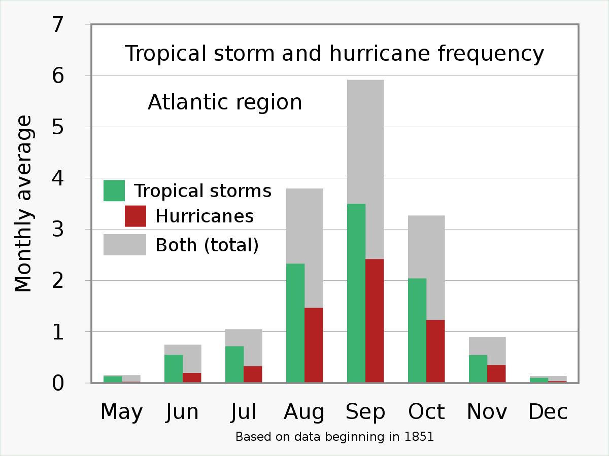
Annual Peak Of Atlantic Hurricane Season Has Arrived
Sept. 10 is when the Atlantic Basin has had the most hurricanes and named storms.www.wunderground.com

That would be a different thread. Why don't you go start one.Interestingly and being ignored right now....
Tropical activity in the Pacific at record lows....
What's up with that?
I'm sure the Jamaicans are pleased as punch. And the weakening you see will be due to the storm smashing into the Yucatan Peninsula.
And, of course, we now have the first Cat 5 to EVER appear in June. And the same storm went from a tropical depression to a Cat 4 in less than 48 hours; both these ocurrences due to the extraordinarily warm Atlantic. So, you still taking bets about the season?
I'm sure the Jamaicans are pleased as punch. And the weakening you see will be due to the storm smashing into the Yucatan Peninsula.
Northern Hemisphere | 12.7375 | 67 | 19% | 575 | 648 |
|---|---|---|---|---|---|
10.45 | 43 | 24% | 298 | 275 | |
0 | 14 | 0% | 132 | 165 | |
| 0 | 1 | 0% | 122 | 146 | |
North Indian | 2.2875 | 7 | 32% | 23 | 60 |
Southern Hemisphere | 169.958 | 209 | 81% | 205 | 244 |
Global | 145.8305 | 239 | 61% | 780 | 881 |
Actually it's due to a higher wind shear before the Yucatan Peninsula, Chicken Little.I'm sure the Jamaicans are pleased as punch. And the weakening you see will be due to the storm smashing into the Yucatan Peninsula.
There hasn't been a Cat 5 storm this early in the season for over 100 years.LOL another hyperbole, how many years of data are you working from?
Are you offering a bet on how this season turns out?Meanwhile Bertha is weakening because it has moved off the area of Barrier Layers that prevents hurricanes from pulling up cooler moisture.
There hasn't been a Cat 5 storm this early in the season for over 100 years.
Are you offering a bet on how this season turns out?