P F Tinmore
Diamond Member
- Dec 6, 2009
- 78,977
- 4,381
- 1,815
- Thread starter
- #3,501
Get a permit from a fake state?
Follow along with the video below to see how to install our site as a web app on your home screen.
Note: This feature may not be available in some browsers.
Get a permit from a fake state?
Get a permit from a fake state?
Get a permit from a fake state?
Don't get a permit.......get bulldozed.
Get a permit from a fake state?
Don't get a permit.......get bulldozed.
You never mention that Israel does not issue permits to Palestinians.
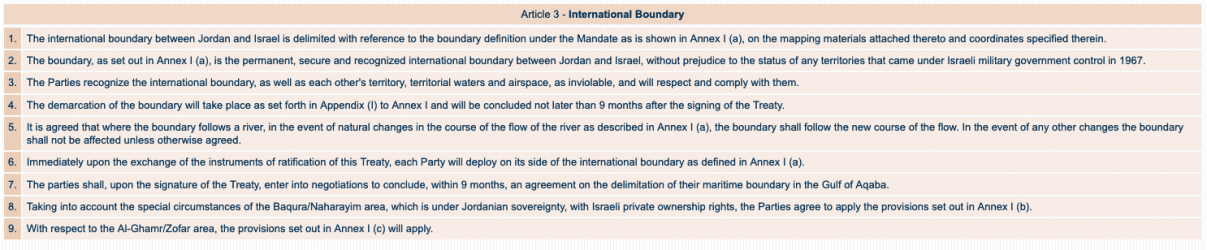
a ) a permanent population;b ) a defined territory;c ) government; andd) capacity to enter into relations with the other states.
(COMMENT)Do you have a 1948 map of Israel or any document where Israel defined its territory?
(COMMENT)What was Israel's so called permanent population?
Get a permit from a fake state?
RE: Who are the Israelis?
⁜→ P F Tinmore, et al,
BLUF: Israel's application as a nation was adjudicated more than a half-Century ago.
a ) a permanent population;b ) a defined territory;c ) government; andd) capacity to enter into relations with the other states.(COMMENT)Do you have a 1948 map of Israel or any document where Israel defined its territory?
Map! Israel don't need no sticking maps.
This question was asked and answered, Friday at 11:46 AM:
(COMMENT)What was Israel's so called permanent population?
The National Jewish Council for the Jewish Stateapplied to the UN (after coordination with the UNPC) pursuant to Part One - B4, Resolution 181 (II). The General Assembly adopted the Resolution for the formation of the Jewish and Arab State.
The Summation of the event were annotated in the Question of Palestine Blue Book.

Most Respectfully,
R
a ) a permanent population;
b ) a defined territory;
c ) government; and
d) capacity to enter into relations with the other states.
Your usual dance.Do you have a 1948 map of Israel or any document where Israel defined its territory?

Normally, cartographers don't make general maps in place under armed struggle disputes.
(COMMENT)Your usual dance.
Why don't you just answer the question?
That still does not answer my question.RE: Who are the Israelis?
⁜→ P F Tinmore, et al,
BLUF: Now you are just being ridiculous!
Normally, cartographers don't make general maps in place under armed struggle disputes.(COMMENT)Your usual dance.
Why don't you just answer the question?
If you can't open the Blue Book to pages 5 and 8, I truly feel sorry for you.
Your attempt to tie some significance to a 1948 Map is merely a subterfuge.
Most Respectfully,
R
(COMMENT)That still does not answer my question.
1948, the most importsnt year for Israel, and nobody made a map. Get outta here. Israel toots its horn more than anybody.
None of those maps define Israel's territory.RE: Who are the Israelis?
⁜→ P F Tinmore, et al,
BLUF: I respond in sound-bite form for your consumption.
(COMMENT)That still does not answer my question.
1948, the most importsnt year for Israel, and nobody made a map. Get outta here. Israel toots its horn more than anybody.
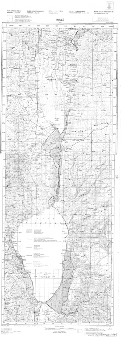
On midnight 14/15 May 1948, the Map was the same as that of [Annex A to Resolution A/RES/181 (II), dated 29 November 1947].
Because the Arab League Forces jumped across their borders, the Annex A Map was superseded by the Forward Edge of the Battle Area (FEBA).
View attachment 454567View attachment 454570
Initial 1948 Cease Fire Lines ----------------------- 1949 Green Line End-State
As the Armed Conflict continued, the FEBA moved back and forth, it was not stationary until early-to-mid-1949 when a ceasefire was arranged and Armistice arrangements set in place. That Armistice Lines (although not intended for that purpose) became the de facto delimitations (borders that something that exists as a result of fact other than law).
In 1967, when the United Nations Emergency Force (UNEF I) was ordered (by no less than General Mohd Fawzy, Chief of Staff of the Egyptian Armed Forces) to completely withdraw at the same time they were making provocative military build-ups and staging forces as if they were planning to move forward and engaged Israeli Forces. This (one of several other factors) precipitated the Six-Day War. While there were many events involved, the outcomes of the Six-Day War, the unilateral move to cut all ties with the West Bank, and the Yom Kipper War were instrumental in setting the ground truth for the territorial control we see today.
You can nit-pick my response all you want. These are my truncated views, inspired by a compilation of any number of scholars that authored entire books, infact volumes of books, on this subject.
Most Respectfully,
R
Once again Tinmore, just because YOU refuse to accept that Israel exists, it does not erase her from the map. Your childish questions and comments mean nothing.None of those maps define Israel's territory.RE: Who are the Israelis?
⁜→ P F Tinmore, et al,
BLUF: I respond in sound-bite form for your consumption.
(COMMENT)That still does not answer my question.
1948, the most importsnt year for Israel, and nobody made a map. Get outta here. Israel toots its horn more than anybody.
On midnight 14/15 May 1948, the Map was the same as that of [Annex A to Resolution A/RES/181 (II), dated 29 November 1947].
Because the Arab League Forces jumped across their borders, the Annex A Map was superseded by the Forward Edge of the Battle Area (FEBA).
View attachment 454567View attachment 454570
Initial 1948 Cease Fire Lines ----------------------- 1949 Green Line End-State
As the Armed Conflict continued, the FEBA moved back and forth, it was not stationary until early-to-mid-1949 when a ceasefire was arranged and Armistice arrangements set in place. That Armistice Lines (although not intended for that purpose) became the de facto delimitations (borders that something that exists as a result of fact other than law).
In 1967, when the United Nations Emergency Force (UNEF I) was ordered (by no less than General Mohd Fawzy, Chief of Staff of the Egyptian Armed Forces) to completely withdraw at the same time they were making provocative military build-ups and staging forces as if they were planning to move forward and engaged Israeli Forces. This (one of several other factors) precipitated the Six-Day War. While there were many events involved, the outcomes of the Six-Day War, the unilateral move to cut all ties with the West Bank, and the Yom Kipper War were instrumental in setting the ground truth for the territorial control we see today.
You can nit-pick my response all you want. These are my truncated views, inspired by a compilation of any number of scholars that authored entire books, infact volumes of books, on this subject.
Most Respectfully,
R
There are neighboring nations to Israel that share lines of demarcation marking borders. Like many things you are in denial of, the data has been presented to you countless times yet you choose childlike denials.None of those maps define Israel's territory.RE: Who are the Israelis?
⁜→ P F Tinmore, et al,
BLUF: I respond in sound-bite form for your consumption.
(COMMENT)That still does not answer my question.
1948, the most importsnt year for Israel, and nobody made a map. Get outta here. Israel toots its horn more than anybody.
On midnight 14/15 May 1948, the Map was the same as that of [Annex A to Resolution A/RES/181 (II), dated 29 November 1947].
Because the Arab League Forces jumped across their borders, the Annex A Map was superseded by the Forward Edge of the Battle Area (FEBA).
View attachment 454567View attachment 454570
Initial 1948 Cease Fire Lines ----------------------- 1949 Green Line End-State
As the Armed Conflict continued, the FEBA moved back and forth, it was not stationary until early-to-mid-1949 when a ceasefire was arranged and Armistice arrangements set in place. That Armistice Lines (although not intended for that purpose) became the de facto delimitations (borders that something that exists as a result of fact other than law).
In 1967, when the United Nations Emergency Force (UNEF I) was ordered (by no less than General Mohd Fawzy, Chief of Staff of the Egyptian Armed Forces) to completely withdraw at the same time they were making provocative military build-ups and staging forces as if they were planning to move forward and engaged Israeli Forces. This (one of several other factors) precipitated the Six-Day War. While there were many events involved, the outcomes of the Six-Day War, the unilateral move to cut all ties with the West Bank, and the Yom Kipper War were instrumental in setting the ground truth for the territorial control we see today.
You can nit-pick my response all you want. These are my truncated views, inspired by a compilation of any number of scholars that authored entire books, infact volumes of books, on this subject.
Most Respectfully,
R
Get a permit from a fake state?
You’re stuck on stupid. States are modern creations and Israeli statehood came into existence in 1948. However, Israel dates back thousands of years...That still does not answer my question.RE: Who are the Israelis?
⁜→ P F Tinmore, et al,
BLUF: Now you are just being ridiculous!
Normally, cartographers don't make general maps in place under armed struggle disputes.(COMMENT)Your usual dance.
Why don't you just answer the question?
If you can't open the Blue Book to pages 5 and 8, I truly feel sorry for you.
Your attempt to tie some significance to a 1948 Map is merely a subterfuge.
Most Respectfully,
R
1948, the most importsnt year for Israel, and nobody made a map. Get outta here. Israel toots its horn more than anybody.
(COMMENT)None of those maps define Israel's territory.
(COMMENT)None of those maps define Israel's territory.
I have already given my concernes about international law and all that ridiculous stuff.RE: Who are the Israelis?
⁜→ P F Tinmore, et al,
BLUF: Part II
(COMMENT)None of those maps define Israel's territory.
You've been given the International Treaties.
You've been given the applicable clauses.
You've been given an explanation as to how the Arab League interrupted the processes put in place that end with today's layout.
You've been given the same Maps or equivalents over and over again, in which you always find some ridiculous fault.
(Ω • The END)
We are beating a dead horse. I consider this topic buried. You either deny the documentation or accept it. It makes no difference now.
The matter is closed as far as I am concerned.
Most Respectfully,
R