2013 sea ice thread!!!

Really Ian. A flat statement with no links to back it up?


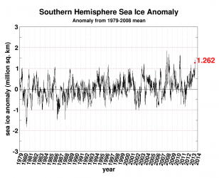
how is this thread any different than the last thread we discussed this on? I couldnt be bothered to dredge up Zwally's presentations yet again. in case you havent noticed, generic 'chicken little' press releases get splashed over the media with google links galore. information contrary to CAGW, even when it comes from organizations like NASA, usually gets little publicity and you actually have to know where to look for it. Zwally made a big fuss over the glaciers losing mass on the penninsula, and in the last throw-away gesture stated that the continent as a whole was gaining almost 50GT per year.

Antarctica is a poster child for ridiculous CAGW alarmist claims. every new paper claims that now they know what is going on. until the next paper comes out and they have to scale back yet again. but they sure love to bring up the factoid about 'if the WAIS collapses the sea level will rise 30 metres' even though the next IPCC report will guestimate about 0.5 millimetre per year, and even that is wrong if Antarctica is really gaining mass.


Your evidence for this is?

Zwally's presentations to NASA in 2011 and 2012. we have discussed it before.
 
Jay Zwally's is the minority opinion. That doesn't mean it's wrong. But it's rather premature to declare Zwally has to be the correct voice.

In any case, Zwally's work is only about Antarctic land ice.
 
Jay Zwally's is the minority opinion. That doesn't mean it's wrong. But it's rather premature to declare Zwally has to be the correct voice.

In any case, Zwally's work is only about Antarctic land ice.


Since satellites began gathering data way back in 1979 the Antarctic sea ice has seen nothing but steady growth.
 

Attachments

  • $seaice_anomaly_antarctic.png
    $seaice_anomaly_antarctic.png
    21 KB · Views: 78
Since satellites began gathering data way back in 1979 the Antarctic sea ice has seen nothing but steady growth.

As predicted by AGW scientists.

Just a small part of the track record of correct predictions that gives them so much credibility. If your side wants the same credibility, you need to spend several decades making predictions and having them proven to be correct.


Really? Show us three papers from the early 2000's that assert that. Just three.
 
There's a good piece on Scpetical Science about this:

t's important to distinguish between Antarctic land ice and sea ice which are two separate phenomena. Reporting on Antarctic ice often fails to recognise the difference between sea ice and land ice. To summarize the situation with Antarctic ice trends:

Antarctic land ice is decreasing at an accelerating rate
Antarctic sea ice is increasing despite the warming Southern Ocean

Measuring changes in Antarctic land ice mass has been a difficult process due to the ice sheet's massive size and complexity. However, since 2002 the Gravity Recovery and Climate Experiment (GRACE) satellites have been able to comprehensively survey the entire ice sheet. The satellites measure changes in gravity to determine mass variations of the entire Antarctic ice sheet. Initial observations found that that most of Antarctic mass loss comes from Western Antarctica (Velicogna 2007). Meanwhile, from 2002 to 2005, East Antarctica was in approximate mass balance. The ice gained in the interior is roughly balanced by the ice loss at the edges. This is illustrated in Figure 1 which contrasts the ice mass changes in West Antarctica (red) compared to East Antarctica (green):

antarctic_mass2.gif


Is Antarctica losing or gaining ice?
 
Extreme high temps over Alaska and the Canadian Arctic. Many record highs being set.

Canada Weather Map - Current Temperatures of Canada °F or °C - Find Local Weather

Why?

The north polar jetstream is driven by the temp difference between the mid-lat region and the polar region.

When the arctic warms, that delta-T goes down, and the jetstream weakens.

When the jet weakens, it starts meandering like a slow river. Big loops going way up north and way down south.

That lets warm air flow north, and cold air flow south. So you get these warm spells in the Arctic along with cool spells in the lower 48.
 
There's a good piece on Scpetical Science about this:

t's important to distinguish between Antarctic land ice and sea ice which are two separate phenomena. Reporting on Antarctic ice often fails to recognise the difference between sea ice and land ice. To summarize the situation with Antarctic ice trends:

Antarctic land ice is decreasing at an accelerating rate
Antarctic sea ice is increasing despite the warming Southern Ocean

Measuring changes in Antarctic land ice mass has been a difficult process due to the ice sheet's massive size and complexity. However, since 2002 the Gravity Recovery and Climate Experiment (GRACE) satellites have been able to comprehensively survey the entire ice sheet. The satellites measure changes in gravity to determine mass variations of the entire Antarctic ice sheet. Initial observations found that that most of Antarctic mass loss comes from Western Antarctica (Velicogna 2007). Meanwhile, from 2002 to 2005, East Antarctica was in approximate mass balance. The ice gained in the interior is roughly balanced by the ice loss at the edges. This is illustrated in Figure 1 which contrasts the ice mass changes in West Antarctica (red) compared to East Antarctica (green):

antarctic_mass2.gif


Is Antarctica losing or gaining ice?


hmmm, I thought I had already responded to this post. anyways.....

when you look at the graph what do you see? is it really possible that the Antarctic gained 800 gigatons of ice in 2002? when does that graph actually start showing ice loss?

I am always surprised when people read these stories and just gullibly accept the assumptions and conclusions that are implied. did anyone else notice anything odd or did you just look at the dashed trend lines and say, "yup, west is shrinking, east is flat". how many of you actually read the link to SkS? did it make sense to you?


here is another companion graph from that article-

Antarctica_Ice_Mass.gif


hmmm..... so Antarctica did gain 800GT in 2002? and didn't start losing mass until 2006? what????
 
This is kind of cool, an animation of the last month's melt. Requires letting a Java app run, and kind of a big download.

Cryosphere Today - Northern Hemisphere Cryosphere Animation

Nothing earth-shattering. The northwest passage is melting fast, except the west end, which is plugged by 4-meter ice that the storms blew that way, meaning it won't open for a long time, if at all. Ice melt started slow, but has accelerated the past few days. Still way too early to make any calls.

N_stddev_timeseries.png
 
Last edited:
This thread seems to have been abandoned. Why?

There is some interesting sea ice news lately...the group that was going to row a boat through the northwest passage gave up in the middle of july after rowing exactly zero miles through the northwest passage...it is completely blocked with ice. In fact, they didn't even get to the fabled northwest passage.

As concerned as you all seemed to be over melting, I would have thought that this thread would have been jumping over the good news that the ice is doing great this year.

I guess you realy weren't concerned about the ice at all.

It's the standard cut and run warmer BS.. But don't worry as soon as the ice melts somewhere they will make another thread..
 
This thread seems to have been abandoned. Why?

Because "the ice is melting very fast" has already been stated. Not much point in rephrasing that.

Arctic ice levels are really low, but not quite as low as 2012. To an intelligent person, that would mean the arctic is warming. To the gibbering retard crowd, the fact that a record doesn't get broken every year is an excuse to declare warming has stopped. Because yes, they really are that dumb.

There is some interesting sea ice news lately...the group that was going to row a boat through the northwest passage gave up in the middle of july after rowing exactly zero miles through the northwest passage...it is completely blocked with ice. In fact, they didn't even get to the fabled northwest passage.

Passages in 2012 were all late August and early September. Of course it's still ice-blocked. It's still freakin' July. Acting as if that "news" meant something is typical of your poorly informed nature.
 
here is a link to a compilation of information about the Arctic in the first half of the 20th century.
Historic Variations in Arctic sea ice. Part II: 1920-1950 | Climate Etc.

eg.-
Page 12 of Hubert Lamb’s ‘Climate History and the Modern World’ (originally published 1982 using material collated during the previous decade) notes ‘…from around the beginning of the century up to 1940 a substantial climate change was in progress, average temperatures were rising, most of all in the arctic where the sea ice was receding…the almost four and a half decades of near immunity to very cold winters ended abruptly with Europe’s notably severe war winters in 1940, 41 and 42 and another in 1947.’

Page 259 comments ‘…warming was rapid from about 1920 to 1940 …it was during the second and third decades of the (20th) century that the climatic warming became noticeable to everybody, places near the arctic fringe such as Iceland, Spitsbergen and even Toronto experienced warming that was from twice to five times as great… the average total areas of the arctic sea ice seems to have declined by about between 10 and 20% ….when account is also taken of the changes in the atmospheric circulation and hence in the distribution of rainfall and its variability as well, it is hardly too much to say that the twentieth century climate regime from 1920 to 1960 changed the world.’ Page 261 ‘… the frequency of snow and ice decreased generally and the retreat of the glaciers from about 1925 became rapid.’

I am not saying that ice extent numbers are cherry picked, but it was fortuitous for the warmers that satellite coverage started in earnest about 1979, when levels were high. from AR1, the first IPCC report-
screenhunter_170-jun-15-11-10-1.jpg
 
Quote:
Page 12 of Hubert Lamb’s ‘Climate History and the Modern World’ (originally published 1982 using material collated during the previous decade) notes ‘…from around the beginning of the century up to 1940 a substantial climate change was in progress, average temperatures were rising, most of all in the arctic where the sea ice was receding…the almost four and a half decades of near immunity to very cold winters ended abruptly with Europe’s notably severe war winters in 1940, 41 and 42 and another in 1947.’

Page 259 comments ‘…warming was rapid from about 1920 to 1940 …it was during the second and third decades of the (20th) century that the climatic warming became noticeable to everybody, places near the arctic fringe such as Iceland, Spitsbergen and even Toronto experienced warming that was from twice to five times as great… the average total areas of the arctic sea ice seems to have declined by about between 10 and 20% ….when account is also taken of the changes in the atmospheric circulation and hence in the distribution of rainfall and its variability as well, it is hardly too much to say that the twentieth century climate regime from 1920 to 1960 changed the world.’ Page 261 ‘… the frequency of snow and ice decreased generally and the retreat of the glaciers from about 1925 became rapid.’

Compared to this;

http://arctic.atmos.uiuc.edu/cryosphere/IMAGES/seaice.area.arctic.png
 
I am not saying that ice extent numbers are cherry picked, but it was fortuitous for the warmers that satellite coverage started in earnest about 1979, when levels were high.

Let's look at levels for the past century. From Kinnard et al. (2008), reproduced in Polyak et al. (2010) (with graph image web-hosted by Tamino). The trend for the whole century is down. 1979 is a spike higher than the years around it, but lower than the pre-1940 trend. So there goes the "1979 was a high fluke!" theory.

http://bprc.osu.edu/geo/publications/polyak_etal_seaice_QSR_10.pdf

polyakfig2.jpg
 
With Arctic ice melt, ships now ply the Northern Sea Route

Here is possibly one of the rare pluses of climate change.

Melting sea ice means that Arctic shipping is set for a record year, reports the Financial Times.

As of Tuesday, 232 ships had received permission from Russia's Northern Sea Route Administration to transit what used to be called the Northeastern Passage.

How quickly things change.

in 2009, two German ships made history by navigating from South Korea to Rotterdam via the Northeast Passage.

"Plenty have tried," noted a report in Time that year. "For centuries, sailors have searched for a shortcut between the Atlantic and Pacific oceans through the icy waters off Russia's northern coast. Otherwise known as the Northern Sea Route, the passage — from Siberia to the Bering Strait — promised a speedy sea route between Europe and Asia for anyone who could make it. But caked in ice during winter and pretty much inhospitable because of floating ice in summer, the route has remained largely off-limits."

And then, the report noted, "Global warming may change that."

In 2010, four vessels sailed through the Northeastern route.

In 2012, 46 sailed through.

And now, 232. So far.

The northern route shaves ten days off the time to sail between Rotterdam and Kobe, in Japan, or Busan, in South Korea. Instead of 33 days via the Suez Canal, it takes 23 via the formerly ice-bound waters

Read more at With Arctic ice melt, ships now ply the Northern Sea Route


Oh looky, it's so rare for the ice to be not there that it wasn't until 1878 that Nordenskiöld first was able to transit that area. Between 1877 and 1919, 75 of 122 convoys that attempted the passage succeeded. Yeppers it's so uncommon that hundreds of vessels did it before the turn of LAST century:cuckoo:

Read a damned book on history sometime....

http://www.encyclopedia.com/topic/Northeast_Passage.aspx
 
here is a link to a compilation of information about the Arctic in the first half of the 20th century.
Historic Variations in Arctic sea ice. Part II: 1920-1950 | Climate Etc.

eg.-
Page 12 of Hubert Lamb’s ‘Climate History and the Modern World’ (originally published 1982 using material collated during the previous decade) notes ‘…from around the beginning of the century up to 1940 a substantial climate change was in progress, average temperatures were rising, most of all in the arctic where the sea ice was receding…the almost four and a half decades of near immunity to very cold winters ended abruptly with Europe’s notably severe war winters in 1940, 41 and 42 and another in 1947.’

Page 259 comments ‘…warming was rapid from about 1920 to 1940 …it was during the second and third decades of the (20th) century that the climatic warming became noticeable to everybody, places near the arctic fringe such as Iceland, Spitsbergen and even Toronto experienced warming that was from twice to five times as great… the average total areas of the arctic sea ice seems to have declined by about between 10 and 20% ….when account is also taken of the changes in the atmospheric circulation and hence in the distribution of rainfall and its variability as well, it is hardly too much to say that the twentieth century climate regime from 1920 to 1960 changed the world.’ Page 261 ‘… the frequency of snow and ice decreased generally and the retreat of the glaciers from about 1925 became rapid.’

I am not saying that ice extent numbers are cherry picked, but it was fortuitous for the warmers that satellite coverage started in earnest about 1979, when levels were high. from AR1, the first IPCC report-
screenhunter_170-jun-15-11-10-1.jpg


here is mamooth's graph-

polyakfig2.jpg


one was compiled at the beginning of global warming hysteria before it was known just how much 'facts and figures' could be 'adjusted'. the other during the heyday of global warming hysteria when everyone was climbing over each other to print something even more alarming than the last.

can you tell which one is which?

hey mamooth- hard to believe the two graphs are of the same thing, in the same place, isn't it? the overlapping portion of the two graphs aren't exactly identical, are they?
 

Forum List

Back
Top