The world renowned Gaza veterinary school.
Navigation
Install the app
How to install the app on iOS
Follow along with the video below to see how to install our site as a web app on your home screen.
Note: This feature may not be available in some browsers.
More options
You are using an out of date browser. It may not display this or other websites correctly.
You should upgrade or use an alternative browser.
You should upgrade or use an alternative browser.
Who Are The Palestinians? Part 2
- Thread starter Art__Allm
- Start date
- Status
- Not open for further replies.
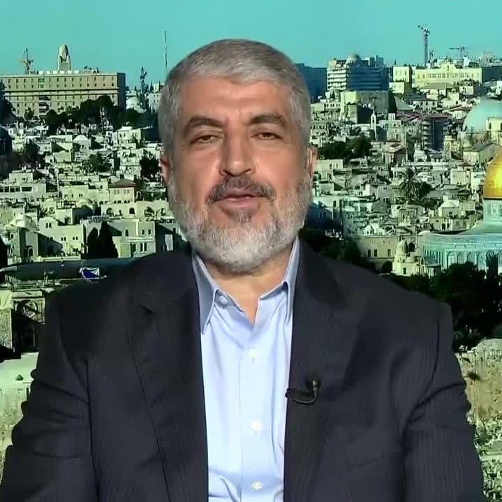
Head Of Hamas Diaspora Office Khaled Mash'al: Hamas Seeks To Restore Ties With Arab Countries, Especially Saudi Arabia; We Adhere To The Ideology Of The Muslim Brotherhood But Are An Independent Movement
Head of Hamas Diaspora Office Khaled Mash'al said that Hamas seeks to restore ties with Arab countries that had previous...
The Pally terrorists are having to reconcile their fawning admiration for the Shia Iranian mullocrats, (and the Sbia welfare money), which puts them the outs with the Sunni Arab world.
Last edited:
Sixties Fan
Diamond Member
- Mar 6, 2017
- 58,335
- 11,054
- 2,140
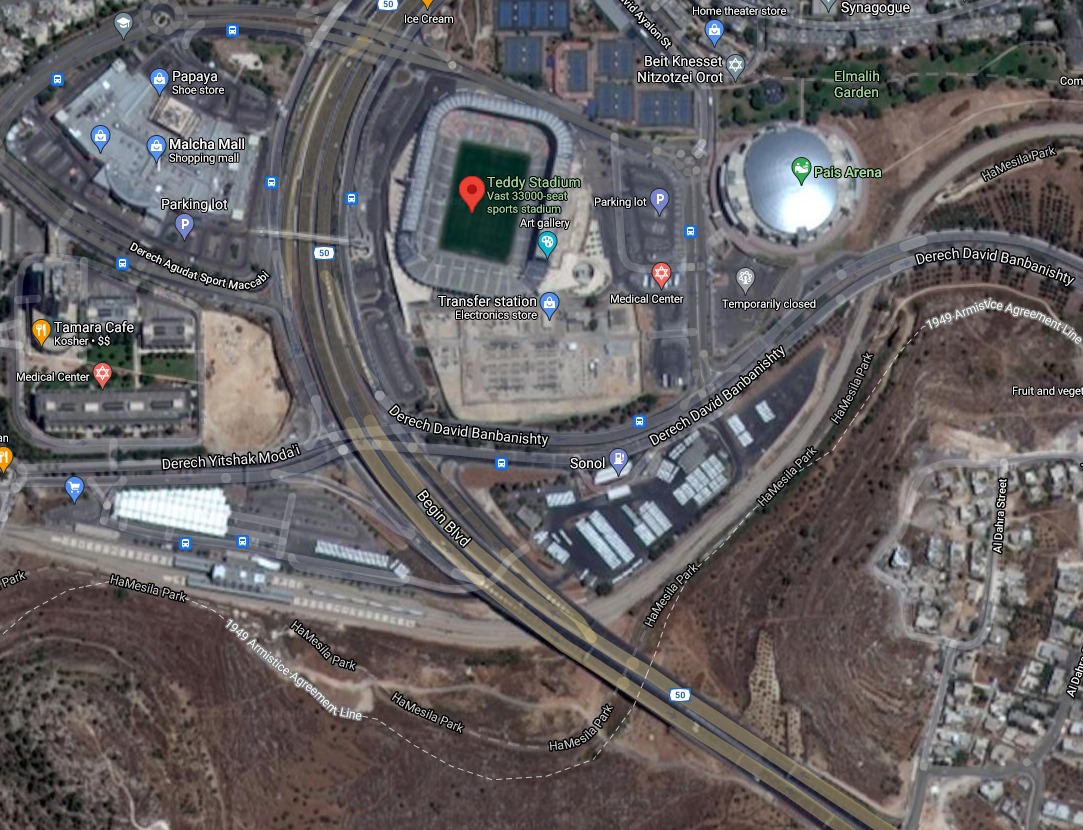
Teddy Stadium, where the match will be played, is in the part of Jerusalem controlled by Israel since 1948.
You can see here that the stadium was built north of the 1949 armistice line.

Rajoub is lying.

There are other objections to them match. Beitar is known for its racist, anti-Arab fans. However, in December, Sheikh Hamad bin Khalifa Al Nahyan of the UAE royal family bought 50% of the club, so it seems like that argument against the match is not very effective any more.
(full article online)

 elderofziyon.blogspot.com
You can see here that the stadium was built north of the 1949 armistice line.
Rajoub is lying.

There are other objections to them match. Beitar is known for its racist, anti-Arab fans. However, in December, Sheikh Hamad bin Khalifa Al Nahyan of the UAE royal family bought 50% of the club, so it seems like that argument against the match is not very effective any more.
(full article online)
Palestinians complaining about football match between Beitar Jerusalem and Barcelona, falsely claiming that it will be played in "occupied" east Jerusalem
Blogging about Israel and the Arab world since, oh, forever.
elderofziyon.blogspot.com
Surprising no one, the UN is issuing another sloppy propaganda piece that confirms again the collection of hacks and misfits serve an agenda.

Report: UN’s Palestine Monitor Ignored Palestinian Authority Rights Abuses.
Report: UN’s Palestine Monitor Ignored
Palestinian Authority Rights Abuses
GENEVA, July 9, 2021 — Ahead of today’s United Nations Human Rights Council’s debate with its monitor on Palestinian rights Michael Lynk, the Geneva-based non-governmental organization UN Watch released a report accusing him of systematically ignoring violations by the Palestinian Authority and Hamas, and the group’s director Hillel Neuer will be taking the floor this afternoon to challenge the UN official.
Report: UN's Palestine Monitor Ignored Palestinian Authority Rights Abuses - UN Watch
PRESS RELEASE Report: UN’s Palestine Monitor Ignored Palestinian Authority Rights Abuses GENEVA, July 9, 2021 — Ahead of today’s United Nations Human Rights Council’s debate with its monitor on Palestinian rights Michael Lynk, the Geneva-based non-governmental organization UN Watch released a...
unwatch.org
Report: UN’s Palestine Monitor Ignored Palestinian Authority Rights Abuses.
Report: UN’s Palestine Monitor Ignored
Palestinian Authority Rights Abuses
GENEVA, July 9, 2021 — Ahead of today’s United Nations Human Rights Council’s debate with its monitor on Palestinian rights Michael Lynk, the Geneva-based non-governmental organization UN Watch released a report accusing him of systematically ignoring violations by the Palestinian Authority and Hamas, and the group’s director Hillel Neuer will be taking the floor this afternoon to challenge the UN official.
Sixties Fan
Diamond Member
- Mar 6, 2017
- 58,335
- 11,054
- 2,140
“There is a wing of the pro-Israel establishment in the U.S.,” the Washington Post’s Ishaan Tharoor tweeted on May 28, 2021, “for whom simply recognizing the humanity of Palestinians is beyond the pale.” The World Views columnist added: “Even the most simple attempt at centering the Palestinian experience can constitute ‘blood libel.’ It’d be funny if it wasn’t so sick.”
Tharoor often pretends to care about Palestinians. The Post employee has authored dozens of omission-laden columns where he blames the Jewish state for a myriad of issues confronting the Palestinian people. But when Israel’s involvement can’t be conjured—when, for example, Palestinian leaders are brutally repressing their own people—Tharoor can’t be troubled to write an honest assessment.
Take, for example, the recent crackdown by the Palestinian Authority, which rules over the majority of Palestinian Arabs.
(full article online)
 www.camera.org
Tharoor often pretends to care about Palestinians. The Post employee has authored dozens of omission-laden columns where he blames the Jewish state for a myriad of issues confronting the Palestinian people. But when Israel’s involvement can’t be conjured—when, for example, Palestinian leaders are brutally repressing their own people—Tharoor can’t be troubled to write an honest assessment.
Take, for example, the recent crackdown by the Palestinian Authority, which rules over the majority of Palestinian Arabs.
(full article online)
When the Washington Post’s World View Doesn’t Include Palestinians
The Washington Post's World View column provides disproportionate, and often misleading, analysis on Israel, much of which castigates the Jewish state for supposedly repressing
www.camera.org
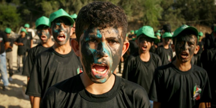
Children represent the next generation of sociopaths who can be conscripted as war materiel by the various islamic terrorist franchises. They hope to reap political capital, at least, from their deaths under retaliatory strikes from the Israeli military. Who is it that has placed children in the line of fire? Not the Israelis, who have done all that any combatant could do to warn them of impending strikes. .
 www.algemeiner.com
Palestinian youths at a graduation ceremony for a military-style camp organized by the Hamas terror group in Gaza, Aug. 18, 2017. Photo: Abed Rahim Khatib/Flash90.
Another summer, another terrorist training camp for Palestinian children.
Hamas Is Abusing Children, and the World Is Complicit
Palestinian youths at a graduation ceremony for a military-style camp organized by the Hamas terror group in Gaza, Aug. 18, …
www.algemeiner.com
Hamas Is Abusing Children, and the World Is Complicit
Palestinian youths at a graduation ceremony for a military-style camp organized by the Hamas terror group in Gaza, Aug. 18, 2017. Photo: Abed Rahim Khatib/Flash90.
Another summer, another terrorist training camp for Palestinian children.
Sixties Fan
Diamond Member
- Mar 6, 2017
- 58,335
- 11,054
- 2,140
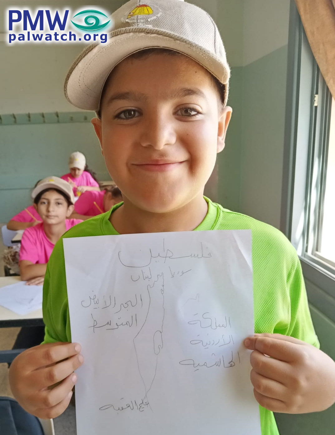
A Palestinian boy who is participating in a Fatah summer camp in Nablus proudly holds up a drawing of “Palestine” that he drew at camp. The map erases the entire State of Israel.
The boy’s drawing shows the map used by the PA in all frameworks that presents all of Israel together with the PA areas as “Palestine.” “Palestine” is written at the top of the drawing, while to the north of “Palestine” is written “Lebanon,” to the east “Syria” and “Jordan,” to the west “the Mediterranean Sea,” and to the south “the Gulf of Aqaba.”
There is no Israel.
The boy’s “geographical knowledge” - which seems to have been reinforced at the Fatah summer camp - is consistent with the PA’s decade-long indoctrination of Palestinians to believe that Israel has no right to exist in any borders and that “Palestine” will be “liberated from the Sea to the River.”
An additional message taught by Fatah in Nablus to kids at the camp was the importance of boycotting Israeli products:
(full article online)
 palwatch.org
The boy’s drawing shows the map used by the PA in all frameworks that presents all of Israel together with the PA areas as “Palestine.” “Palestine” is written at the top of the drawing, while to the north of “Palestine” is written “Lebanon,” to the east “Syria” and “Jordan,” to the west “the Mediterranean Sea,” and to the south “the Gulf of Aqaba.”
There is no Israel.
The boy’s “geographical knowledge” - which seems to have been reinforced at the Fatah summer camp - is consistent with the PA’s decade-long indoctrination of Palestinians to believe that Israel has no right to exist in any borders and that “Palestine” will be “liberated from the Sea to the River.”
An additional message taught by Fatah in Nablus to kids at the camp was the importance of boycotting Israeli products:
(full article online)
What did you learn in summer camp today? Young boy erases Israel | PMW Analysis
A Palestinian boy who is participating in a Fatah summer camp in Nablus proudly holds up a drawing of “Palestine” that he drew at camp. The map erases the entire State of Israel
palwatch.org
P F Tinmore
Diamond Member
- Dec 6, 2009
- 78,979
- 4,381
- 1,815
His map is geographically correct.A Palestinian boy who is participating in a Fatah summer camp in Nablus proudly holds up a drawing of “Palestine” that he drew at camp. The map erases the entire State of Israel.
The boy’s drawing shows the map used by the PA in all frameworks that presents all of Israel together with the PA areas as “Palestine.” “Palestine” is written at the top of the drawing, while to the north of “Palestine” is written “Lebanon,” to the east “Syria” and “Jordan,” to the west “the Mediterranean Sea,” and to the south “the Gulf of Aqaba.”
There is no Israel.
The boy’s “geographical knowledge” - which seems to have been reinforced at the Fatah summer camp - is consistent with the PA’s decade-long indoctrination of Palestinians to believe that Israel has no right to exist in any borders and that “Palestine” will be “liberated from the Sea to the River.”
An additional message taught by Fatah in Nablus to kids at the camp was the importance of boycotting Israeli products:
(full article online)
What did you learn in summer camp today? Young boy erases Israel | PMW Analysis
A Palestinian boy who is participating in a Fatah summer camp in Nablus proudly holds up a drawing of “Palestine” that he drew at camp. The map erases the entire State of Israel
Sixties Fan
Diamond Member
- Mar 6, 2017
- 58,335
- 11,054
- 2,140
For learned Jew haters who are intent in making sure that Jews will never be sovereign over their own homeland.His map is geographically correct.A Palestinian boy who is participating in a Fatah summer camp in Nablus proudly holds up a drawing of “Palestine” that he drew at camp. The map erases the entire State of Israel.
The boy’s drawing shows the map used by the PA in all frameworks that presents all of Israel together with the PA areas as “Palestine.” “Palestine” is written at the top of the drawing, while to the north of “Palestine” is written “Lebanon,” to the east “Syria” and “Jordan,” to the west “the Mediterranean Sea,” and to the south “the Gulf of Aqaba.”
There is no Israel.
The boy’s “geographical knowledge” - which seems to have been reinforced at the Fatah summer camp - is consistent with the PA’s decade-long indoctrination of Palestinians to believe that Israel has no right to exist in any borders and that “Palestine” will be “liberated from the Sea to the River.”
An additional message taught by Fatah in Nablus to kids at the camp was the importance of boycotting Israeli products:
(full article online)
What did you learn in summer camp today? Young boy erases Israel | PMW Analysis
A Palestinian boy who is participating in a Fatah summer camp in Nablus proudly holds up a drawing of “Palestine” that he drew at camp. The map erases the entire State of Israel
What a surprise !!!!
Only in the alternate reality of the Arab-Moslem squatter.His map is geographically correct.A Palestinian boy who is participating in a Fatah summer camp in Nablus proudly holds up a drawing of “Palestine” that he drew at camp. The map erases the entire State of Israel.
The boy’s drawing shows the map used by the PA in all frameworks that presents all of Israel together with the PA areas as “Palestine.” “Palestine” is written at the top of the drawing, while to the north of “Palestine” is written “Lebanon,” to the east “Syria” and “Jordan,” to the west “the Mediterranean Sea,” and to the south “the Gulf of Aqaba.”
There is no Israel.
The boy’s “geographical knowledge” - which seems to have been reinforced at the Fatah summer camp - is consistent with the PA’s decade-long indoctrination of Palestinians to believe that Israel has no right to exist in any borders and that “Palestine” will be “liberated from the Sea to the River.”
An additional message taught by Fatah in Nablus to kids at the camp was the importance of boycotting Israeli products:
(full article online)
What did you learn in summer camp today? Young boy erases Israel | PMW Analysis
A Palestinian boy who is participating in a Fatah summer camp in Nablus proudly holds up a drawing of “Palestine” that he drew at camp. The map erases the entire State of Israel
P F Tinmore
Diamond Member
- Dec 6, 2009
- 78,979
- 4,381
- 1,815
That is Palestine inside its international borders.For learned Jew haters who are intent in making sure that Jews will never be sovereign over their own homeland.His map is geographically correct.A Palestinian boy who is participating in a Fatah summer camp in Nablus proudly holds up a drawing of “Palestine” that he drew at camp. The map erases the entire State of Israel.
The boy’s drawing shows the map used by the PA in all frameworks that presents all of Israel together with the PA areas as “Palestine.” “Palestine” is written at the top of the drawing, while to the north of “Palestine” is written “Lebanon,” to the east “Syria” and “Jordan,” to the west “the Mediterranean Sea,” and to the south “the Gulf of Aqaba.”
There is no Israel.
The boy’s “geographical knowledge” - which seems to have been reinforced at the Fatah summer camp - is consistent with the PA’s decade-long indoctrination of Palestinians to believe that Israel has no right to exist in any borders and that “Palestine” will be “liberated from the Sea to the River.”
An additional message taught by Fatah in Nablus to kids at the camp was the importance of boycotting Israeli products:
(full article online)
What did you learn in summer camp today? Young boy erases Israel | PMW Analysis
A Palestinian boy who is participating in a Fatah summer camp in Nablus proudly holds up a drawing of “Palestine” that he drew at camp. The map erases the entire State of Israel
What a surprise !!!!
Look it up.
Sixties Fan
Diamond Member
- Mar 6, 2017
- 58,335
- 11,054
- 2,140
This is not a common video to be circulating the internet. She was raised as a “Palestinian” woman but mentions in the video that she is no longer a “Palestinian.” The truth makes sense to her. Everything she says in this video exposes what the “Palestinian” culture is about.
This woman exposes what Ramadan is all about. And what about all the violence that has taken place in Al-Aqsa mosque? She reveals the truth about that as well.

 www.israelunwired.com
This woman exposes what Ramadan is all about. And what about all the violence that has taken place in Al-Aqsa mosque? She reveals the truth about that as well.
"Palestinian" Woman Makes Video Exposing the Crimes of Her Own People
Wow, now this is a rare video.
Toddsterpatriot
Diamond Member
His map is geographically correct.
When has there ever been a Palestinian state in that region?
Toddsterpatriot
Diamond Member
That is Palestine inside its international borders.
Who were the signers of what agreements that solidified those borders?
Link?
Sixties Fan
Diamond Member
- Mar 6, 2017
- 58,335
- 11,054
- 2,140
The message is that any infighting takes away from the battle against Israel, and ends up strengthening the Zionist enemy.
Al-Aloul said that opposing Israel is the main challenge for Palestinians, and they could not afford any internal dissent which he called "secondary conflict."
"O others, who are taking us towards a secondary conflict, where are you going? Is this not in the interest of the occupation? We are fighting a battle against the occupation, isn't this a relief to the occupation? We tell you that we are in Fatah support unity, pluralism with other opinions, but we have the ability to distinguish [between legitimate opinions and opposition to Fatah.]
And who makes the decision of what kinds of criticism is legitimate and which kind results in beatings and imprisonment? Why, it is people like Al-Aloul!
(full article online)
 elderofziyon.blogspot.com
Al-Aloul said that opposing Israel is the main challenge for Palestinians, and they could not afford any internal dissent which he called "secondary conflict."
"O others, who are taking us towards a secondary conflict, where are you going? Is this not in the interest of the occupation? We are fighting a battle against the occupation, isn't this a relief to the occupation? We tell you that we are in Fatah support unity, pluralism with other opinions, but we have the ability to distinguish [between legitimate opinions and opposition to Fatah.]
And who makes the decision of what kinds of criticism is legitimate and which kind results in beatings and imprisonment? Why, it is people like Al-Aloul!
(full article online)
Deputy head of Fatah warns critics not to "provoke" them - because they value unity
Blogging about Israel and the Arab world since, oh, forever.
elderofziyon.blogspot.com
Sixties Fan
Diamond Member
- Mar 6, 2017
- 58,335
- 11,054
- 2,140
Analysts at the leading think tank the Foundation for Defense of Democracies, in testimony before Congress, have noted the “significant overlap between employees from this Hamas-supporting organization and the American Muslims for Palestine network.” And one of America’s oldest anti-racism groups, the Anti-Defamation League, notes, “AMP has its organizational roots in the Islamic Association of Palestine (IAP), an anti-Semitic group that served as the main propaganda arm for Hamas in the United States until it was dissolved in 2004.”
AMP officials do not work particularly hard to conceal their views. The current AMP director, Osama Abuirshaid, has praised Hamas as “an army for liberation” whose fighters “rise up for the blood of martyrs.”
That anti-Jewish, pro-terror organizations such as AMP are now turning to cryptocurrency schemes for donations is worrying. Other organizations and law enforcement agencies have increasingly pointed to the growing use of cryptocurrency — particularly the anonymity that such trading offers — as a lucrative source of income and opaqueness for violent Islamist organizations and their lawful cheerleaders in the West.
In June, following clashes between Israel and Hamas, U.S. Congressmen Josh Gottheimer (D-N.J.) and Brian Mast (R-Fla.) introduced bipartisan legislation seeking to impose additional financial sanctions on the Gaza terrorist group, in the wake of reports of “a surge in cryptocurrency donations to Hamas since the start of the conflict, circumventing international sanctions.”
(full article online)

 spectator.org
AMP officials do not work particularly hard to conceal their views. The current AMP director, Osama Abuirshaid, has praised Hamas as “an army for liberation” whose fighters “rise up for the blood of martyrs.”
That anti-Jewish, pro-terror organizations such as AMP are now turning to cryptocurrency schemes for donations is worrying. Other organizations and law enforcement agencies have increasingly pointed to the growing use of cryptocurrency — particularly the anonymity that such trading offers — as a lucrative source of income and opaqueness for violent Islamist organizations and their lawful cheerleaders in the West.
In June, following clashes between Israel and Hamas, U.S. Congressmen Josh Gottheimer (D-N.J.) and Brian Mast (R-Fla.) introduced bipartisan legislation seeking to impose additional financial sanctions on the Gaza terrorist group, in the wake of reports of “a surge in cryptocurrency donations to Hamas since the start of the conflict, circumventing international sanctions.”
(full article online)
The Rise of the Crypto-Islamists - The American Spectator | USA News and PoliticsThe American Spectator | USA News and Politics
Will fundraising methods like using cryptocurrencies to launder money be adopted by other Islamists? Almost certainly.
spectator.org
Sixties Fan
Diamond Member
- Mar 6, 2017
- 58,335
- 11,054
- 2,140
The United Nations food agency recently sounded the alarm as Madagascar experiences its worst drought in decades, with one million people facing potential starvation. In war-ravaged Yemen, 20 million face hunger. In Venezuela, one out of three is struggling to meet minimum nutrition requirements as the Maduro regime sucks the country dry.
All examples of where Michael Fakhri, the UN Human Rights Council’s “right to food” monitor should be taking a keen interest. Yet Fakhri has never issued a press release on any of these. Instead, his attention has recently turned to attacking Israel as an “apartheid state” and calling for it to be boycotted.
The Canadian-Lebanese law professor was appointed by the UN in 2020 as special rapporteur on the right to food. He teaches human rights and food law at the University of Oregon, theoretically bringing relevant expertise.
However, the UN position, initiated two decades ago by Cuba, was politicized from the start, with Havana using its influence to appoint “independent experts” with an anti-Western, anti-US and anti-Israel agenda.
In 2019, Fakhri described Canada as a “settler colony” which he accused of committing a “race-based genocide against indigenous peoples” that is “ongoing.” That Fakhri occupies a UN post supported by anti-Western dictatorships is unsurprising.
During the May 2021 war between Hamas and Israel, Fakhri used his position to co-sign another biased UN statement that condemned Israel for “discrimination and segregation,” and for its “vast asymmetry of power.”
Fakhri also signed a letter calling on the International Criminal Court to investigate the Sheikh Jarrah situation, accusing Israel of “crimes against humanity” and “apartheid.”
The UN’s code of conduct calls on mandate-holders to “ensure that their personal political opinions are without prejudice to the execution of their mission.” It also calls for impartiality. Yet Fakhri’s open support for BDS, a movement that promotes the end of Israel as a Jewish state, demonstrates the opposite.
The code of conduct calls for “upholding the highest standards of integrity.” It is unlikely that this includes advocating breaking the law in a democratic state, yet Fakhri has done exactly that.
(full article online)

 www.jpost.com
All examples of where Michael Fakhri, the UN Human Rights Council’s “right to food” monitor should be taking a keen interest. Yet Fakhri has never issued a press release on any of these. Instead, his attention has recently turned to attacking Israel as an “apartheid state” and calling for it to be boycotted.
The Canadian-Lebanese law professor was appointed by the UN in 2020 as special rapporteur on the right to food. He teaches human rights and food law at the University of Oregon, theoretically bringing relevant expertise.
However, the UN position, initiated two decades ago by Cuba, was politicized from the start, with Havana using its influence to appoint “independent experts” with an anti-Western, anti-US and anti-Israel agenda.
In 2019, Fakhri described Canada as a “settler colony” which he accused of committing a “race-based genocide against indigenous peoples” that is “ongoing.” That Fakhri occupies a UN post supported by anti-Western dictatorships is unsurprising.
During the May 2021 war between Hamas and Israel, Fakhri used his position to co-sign another biased UN statement that condemned Israel for “discrimination and segregation,” and for its “vast asymmetry of power.”
Fakhri also signed a letter calling on the International Criminal Court to investigate the Sheikh Jarrah situation, accusing Israel of “crimes against humanity” and “apartheid.”
The UN’s code of conduct calls on mandate-holders to “ensure that their personal political opinions are without prejudice to the execution of their mission.” It also calls for impartiality. Yet Fakhri’s open support for BDS, a movement that promotes the end of Israel as a Jewish state, demonstrates the opposite.
The code of conduct calls for “upholding the highest standards of integrity.” It is unlikely that this includes advocating breaking the law in a democratic state, yet Fakhri has done exactly that.
(full article online)
Politicized UN official abuses food mandate to target Israel - opinion
The UN’s code of conduct calls on mandate-holders to “ensure that their personal political opinions are without prejudice to the execution of their mission.” It also calls for impartiality.
Sixties Fan
Diamond Member
- Mar 6, 2017
- 58,335
- 11,054
- 2,140
If the international community truly wants to aid Gaza residents, purging Hamas’s influence and completely restructuring UNRWA would be far more effective than money or concrete.
(full article online)
The problem with foreign aid for Gaza
If the international community truly wants to aid Gaza residents, purging Hamas’s influence and completely restructuring UNRWA would be far more effective than money or concrete.
- Status
- Not open for further replies.
Similar threads
- Replies
- 47
- Views
- 374
- Replies
- 62
- Views
- 714
- Replies
- 65
- Views
- 1K
- Replies
- 3
- Views
- 275
Latest Discussions
- Replies
- 2
- Views
- 3
- Replies
- 27
- Views
- 57
- Replies
- 266
- Views
- 2K
Forum List
-
-
-
-
-
Political Satire 8496
-
-
-
-
-
-
-
-
-
-
-
-
-
-
-
-
-
-
-
ObamaCare 781
-
-
-
-
-
-
-
-
-
-
-
Member Usernotes 482
-
-
-
-
-
-
-
-
-
-